
| Home |
|
|
|
___ Political Map of Hungary | |
About Hungary |
|
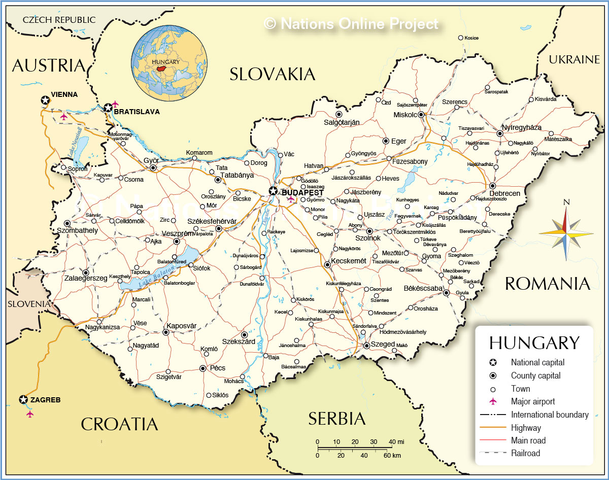
| Map is showing Hungary, a landlocked country in Central Europe. Border Countries are: Austria, Croatia, Romania, Serbia, Slovakia, Slovenia, and Ukraine. Hungary occupies an area of 93,028 km², compared it is about the size of Portugal, or smaller than Iceland, or slightly smaller than the U.S. state of Virginia, or about the same size as Indiana. The Hungarian landscape is mostly flat (Pannonian Basin, better known as Puszta), there are some hills in central north near the border with Slovakia, known as the North Hungarian 'Mountains', within the highest point of Hungary, Kekes (Kékestető) with 1,014 m, located northeast of Gyöngyös in the Mátra mountain range. Largest body of water is Lake Balaton, the largest lake in Central Europe, and one of Hungary's popular tourist destinations. The climate in Hungary is temperate to cold, with cloudy, humid winters and warm summers. Hungary has a population of almost 10 million people (in 2015), the national capital and and largest city is Budapest, spoken language is Hungarian, a Uralic language unrelated to any neighboring language, distantly related to Finnish. Map shows Hungary with surrounding countries, international borders, county capitals, cities, highways, main roads, railroad main lines, and major airports. |
 Bookmark/share this page |
 One World - Nations Online all countries of the world |
|
|
||
 Political Map of Hungary. |
|||||||
| Cities and towns in Hungary: The map shows the location of following Hungarian cities and towns: Largest cities in Hungary are: Budapest (1.6 million), Debrecen (115,000), Miskolc (109,000), Szeged (104,000), Pécs (90,000), Györ (70,000), Nyíregyháza (56,000), Kecskemét (42,000), and Székesfehérvár (42,000) Abony, Ajka, Baja, Balatonboglar, Balatonfüred, Bácsalmas, Berettyóújfalu, Békés, Békéscsaba, Bicske,Cegléd, Celldömölk, Csongrád, Csorna, Derecske, Dévaványa, Dorog, Dunaföldvár, Dunaújváros, Eger, Fegyvernek, Füzesabony, Gödöllö, Gyoma, Gyömro, Gyöngyös, Gyula, Hajduszoboszlo, Hajdúhadház, Hajdúnánas, Hatvan, Heves, Hódmezövásárhely, Isaszeg, Jánoshalma, Jászárokszállás, Jászberény, Kaposvár, Kapuvar, Karcag, Kecel, Keszthely, Kiskörös, Kiskunfélegyháza, Kiskunhalas, Kiskunmajsa, Kisújszállás, Kisvárda, Komarom, Komló, Kunhegyes, Lajosmizse, Makó, Mátészalka, Mezöberény, Mezötúr, Mindszent, Mohács, Monor, Mosonmagyaróvár, Mór, Nadudyar, Nagyatád, Nagykanizsa, Nagykálló, Nagykáta, Nagykörös, Nyírbátor, Orosháza, Oroszlány, Ozd, Pápa, Pilis, Rackeye, Sajószentpéter, Salgótarján, Sarkad, Sarospatak, Sándorfalva, Sárbogárd, Sárvár, Siklós, Siofok, Sopron, Szarvas, Szeghalom, Szekszárd, Szentes, Szerencs, Szigetvár, Szolnok, Szombathely, Tapolca, Tata, Tatabánya, Tiszaföldvár, Tiszavasvari, Törökszentmiklós, Túrkeve, Ujfehértó, Ujszász, Vác, Várpalota, Veszprém, Vése, Vésztö, Zalaegerszeg, Zirc. |
More about Hungary: Cities: Country: Hungary key statistical data. Continent: |
Weather Conditions Budapest:
|
Explore more:
Related Consumer Information:
|
||||
Major Cities in Central and Eastern Europe: Bratislava | Bucharest | Chisinau | Kiev | Minsk | Moscow | Odessa Prague | Riga | Sofia | Sevastopol (Crimea) | Saint Petersburg | Tallinn | Warsaw | Vilnius Maps of other countries and regions in Central and Eastern Europe Belarus Map, Bulgaria Map, Czech Republic Map, Moldova Map, Poland Map, Romania Map, Slovakia Map, Ukraine Map, Crimea Map Searchable Maps of other countries and regions in Central and Eastern Europe Belarus, Bulgaria, Czech Republic, Moldova, Poland Map, Romania Map, Slovakia, Ukraine Map |
One World - Nations Online .:. let's care for this planet Every nation is responsible for the current state of our world. |
| Site Map
| Information Sources | Disclaimer: Privacy Policy, etc. Contact: [email protected] | Copyright © 1998-2021 :: nationsonline.org |
