Nations Online
All Countries in the World
Nations Online All Countries in the World | |
Home  |
___ Satellite View and Map of the City of Budapest (Buda-Pesth) |
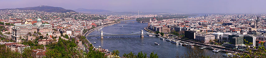 Panorama of Budapest as seen from Gellért Hill, showing from left to right the Matthias Church, Buda Castle, Széchenyi Chain Bridge, Danube Promenade and the Hungarian Parliament. Image: Attila Terbócs |
About Budapest Satellite view is showing Budapest, the national capital of Satellite view is showing Budapest, the national capital of It is a primate city, Hungary's principal political, commercial, cultural, and industrial center. Budapest has an official population of 1,744,000 inhabitants (in 2014), 2.5 million people live in its urban area (2009). Official language is Hungarian. 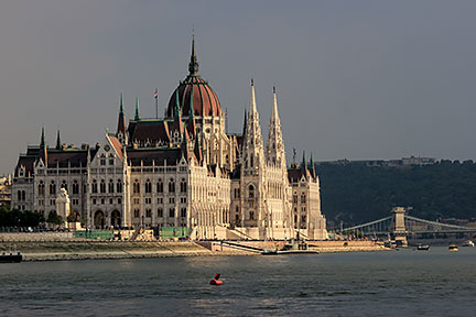 Hungarian Parliament Building at Danube river in Budapest. The House of the Nation (Országház) is the seat of the National Assembly of Hungary. Image: Julian Nitzsche Just zoom in (+) to see Hungary's Parliament Building (Országház) at Danube river, one of the largest in the world. The map shows a city map of Budapest with expressways, main roads and streets, zoom out to find Budapest Ferihegy International Airport (IATA code: BUD) located 16 km (10 miles) in southeast of the center of Budapest. To find a location use the form below. To view just the map, click on the "Map" button. |
|
| To find a location type: street or place, city, optional: state, country. |
Local Time Budapest:
Wednsday-April-17 20:19
Standard Time Zone (CET): UTC/GMT +1 hourCEST (Daylight Saving Time) in use from end of March until end of October. Time zone offset: UTC/GMT +2 hours |
|
φ Latitude, λ Longitude (of Map center; move the map to see coordinates): , |
||||||
| Sorry! Google's pricing policy has made it impossible for us to continue showing Google Maps. We apologize for any inconvenience. Google Map: Searchable Map of the capital city of Hungary, Budapest. City Coordinates: 47°28′19″N 19°03′01″E |
Bookmark/share this page |
|||||
| More about Hungary: Country: Hungary key statistical data. Continent: External Links: Budapest Budapest's official website. Budapest Official Budapest tourism website. Budapest Airport Budapest Ferihegy International Airport website. Wikipedia: Budapest Wikipedia entry Budapest. |
Weather Conditions Budapest:
|
Related Consumer Information:
|
||||
Maps of other countries and regions in Central and Eastern Europe Belarus Map, Bulgaria Map, Czech Republic Map, Moldova Map, Poland Map, Romania Map, Slovakia Map, Ukraine Map Administrative Maps of other countries and regions in Central and Eastern Europe Hungary Administrative Map, Poland Administrative Map, Ukraine Administrative Map Interactive Maps of other countries and regions in Central and Eastern Europe Belarus Interactive Map, Bulgaria Interactive Map, Czech Interactive Republic Map, Moldova Interactive Map, Poland Interactive Map, Romania Interactive Map, Slovakia Interactive Map, Ukraine Interactive Map Other Cities in Eastern Europe: Bratislava | Bucharest | Chisinau | Kiev | Minsk | Moscow | Odessa Prague | Riga | Sofia | Sevastopol (Crimea) | Tallinn | Warsaw | Vilnius All Countries and Territories of Europe |
||||||
Map Help [ show ] |
||||||
One World - Nations Online .:. let's care for this planet Promote that every nation assumes responsibility for our world. Nations Online Project is made to improve cross-cultural understanding and global awareness. More signal - less NOISE |
| Site Map
| Information Sources | Disclaimer | Copyright © 1998-2023 :: nationsonline.org |

