
| Home |
|
|
|
___ Map of Crimea, Ukraine | |
About Crimea |
|
| Map is showing Crimea, a peninsula south of Since Monday the 11th March, Crimea is a "sovereign and independent state", just because Russian President Vladimir Putin said so. He has signed a decree making Crimea a sovereign state. But this will be not recognized by any other country in the world, all other sovereign states are regarding Crimea still as a part of Ukraine. Depicted on the map is the Crimean peninsula with major cities, main roads, railroad, and the location of Simferopol International Airport (IATA code: SIP) |
 Bookmark/share this page |
 One World - Nations Online all countries of the world |
|
|
||
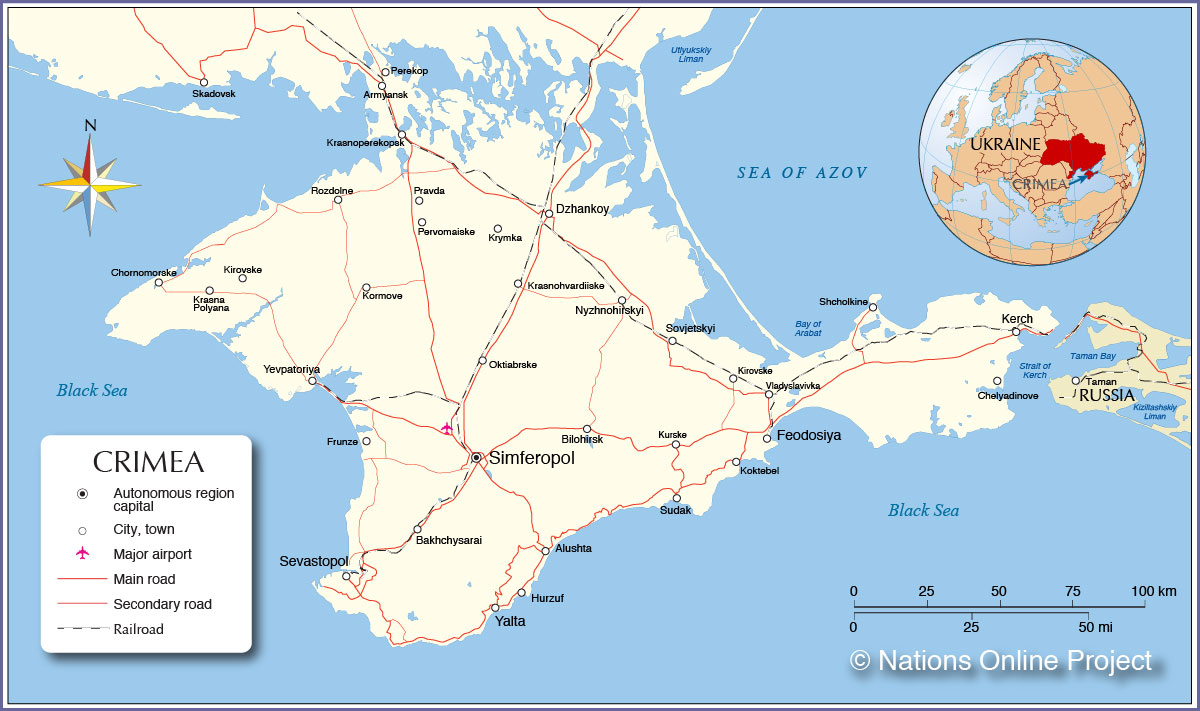 Political Map of Crimea, Ukraine |
| Cities and towns in Crimea: The map shows the location of following Crimean cities: Alushta, Armyansk, Bakhchysarai, Bilohirsk, Chelyadinove, Chornomorske, Dzhankoy, Feodosiya, Hurzuf, Kerch, Kirovske, Koktebel, Kormove, Krasna Polyana, Krasnohvardiiske, Krasnoperekopsk, Krymka, Kurske, Nyzhnohirskyi, Oktiabrske, Pervomaiske, Pravda, Rozdolne, Sevastopol, Shcholkine, Simferopol, Sovjetskyi, Sovkhozne, Sudak, Vladyslavivka, Yalta, and Yevpatoriya. |
More about Ukraine: Cities: Country: Continent: |
Current Weather Conditions Simferopol:
|
Related Consumer Information: |
||||
Maps of other countries and regions in Central and Eastern Europe Belarus Map, Bulgaria Map, Czech Republic Map, Hungary Map, Moldova Map, Poland Map, Romania Map, Slovakia Map Interactive Maps of other countries and regions in Central and Eastern Europe: Belarus Interactive Map, Bulgaria Interactive Map, Czech Interactive Republic Map, Hungary Interactive Map, Moldova Interactive Map, Poland Interactive Map, Romania Interactive Map, Slovakia Interactive Map Other Cities in Eastern Europe: Bratislava | Bucharest | Budapest | Chisinau | Minsk | Moscow | Prague | Sofia | Warsaw Countries and Territories of Europe |
One World - Nations Online .:. let's care for this planet Every nation is responsible for the current state of our world. |
| Site Map
| Information Sources | Disclaimer: Privacy Policy, etc. Contact: [email protected] | Copyright © 1998-2021 :: nationsonline.org |
