Nations Online
All Countries in the World
Nations Online All Countries in the World | |
Home  |
___ Famous Landmarks: Sacred Mountains - Satellite View of Mount Everest |
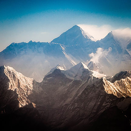
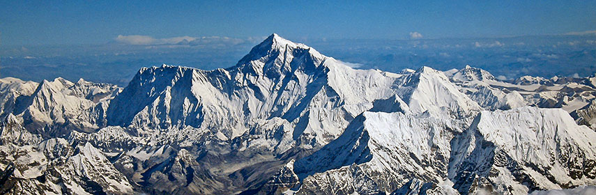 Aerial photo of the Everest Group seen from the south, with the highest mountain on the planet, Mount Everest in center. The three-sided pyramid shaped peak covered with huge glaciers is behind the mountains Nuptse (left) and Lhotse (right, its peak almost in front of Mt. Everest). Mount Everest's height (without snow) is 8 848 m (29 029 ft) above sea level. |
About Mount EverestThe satellite image is showing Mount Everest, sometimes metaphorically called the roof of the world. Mt. Everest is part of the Khumbu Himal mountain range marking the border of Nepal and Tibet (China).Since ancient times the mountain is known in Tibet as Chomolungma, it means 'mother goddess of the universe' or 'Saint Mother'. In Nepal the mountain is known since 1960 as Sagarmatha, it means 'head/god/goddess of the sky'. When British Crown ruled India in the mid 19th century, the mountain was just tagged as peak XV. In the early 19th century (1802) the British started to measure their most valuable possession with a project they named the Great Trigonometric Survey of India. Among the many accomplishments of the Survey were the demarcation of the British territories in India and the measurement of the height of the Himalayan giants, among them Kanchenjunga, then the supposed highest point on earth's surface, "and Dewalagira, the mountain which "school geographies" persisted in calling "the highest in the known world", and as well K2 and Peak IV. To accomplish all of the survey would take about 5 years, but eventually it took them more than 60 years. In 1830, George Everest became Surveyor General of GTS, it was Everest, in need of someone with a proficiency to handle spherical trigonometry, who hired Radhanath Sikdar, an Indian mathematician who joined the GTSI, then aged 19, in December 1831 as a "computor". About 20 years later Radhanath Sikdar devised a formula for 'computing' the heights of the peaks of the Himalaya. In 1852 he proclaimed that he has discovered the highest mountain of the world, and he proved that Peak XV in fact is the tallest mountain above sea level. According to Radhanath’s calculation, the height of the peak turned out as 29,000 ft (8,839.20 m). But Radhanath took it as 29,002 ft (8,839.81 m) because the round figure (29,000 ft) might be misinterpreted as mere approximation. Only in 1865 Radhanath's discovery was made public, (without mentioning his name) and the peak was given its official English name by the British Royal Geographical Society, which named the peak proudly after George Everest, the definitely commendable Welsh surveyor, geographer and Surveyor-General of India. The Himalayas are among the youngest mountain ranges on the planet, their formation began about 40 million years ago. It's the result of a colossal continental collision between two tectonic plates, the Indo-Australian Plate (with what is today India on it) and the Eurasian Plate. Today the highest mountain on earth is a major tourist attraction, admittedly one of the most challenging. Since Edmund Hilary's and Tenzing Norgay's first successful ascent of the mountain in 1953, more than 4,000 people have summited Peak XV, several hundred died trying. |
|
φ Latitude, λ Longitude (of Map center; move the map to see coordinates): , |
||||||
| Google Earth: Searchable map/satellite view of Mount Everest; Sagarmatha, (Nepali) or Chomolungma (Tibetan). (Make sure the Terrain layer in Google Earth is checked.) Mount Everest Peak Coordinates 27°59′17″N 86°55′31″E |
Bookmark/share this page |
|||||
| previous landmark: Mount Fuji |
next landmark: Kilimanjaro | |||||
| More about the Region: Nepal: Nepal key statistical data. Tibet: |
Current Weather Conditions Tingri Tingri is a town in southern Tibet with a population of around 520. Tingri is a base used by mountain climbers preparing to ascend Mount Everest.
External Links Wikipedia: Mount Everest Radhanath Sikdar - First Scientist of modern India Everest Maxed Out National Geographic article about mass tourism on Earth's highest mountain. |
Related Consumer Information:
|
||||
| Countries and Territories of Asia | ||||||
Map Help [ show ] |
||||||
One World - Nations Online .:. let's care for this planet Promote that every nation assumes responsibility for our world. Nations Online Project is made to improve cross-cultural understanding and global awareness. More signal - less NOISE |
| Site Map
| Information Sources | Disclaimer | Copyright © 1998-2023 :: nationsonline.org |