Nations Online
All Countries in the World
Nations Online All Countries in the World | |
Home  |
___ Satellite View and Map of the City of Praia, Cape Verde |
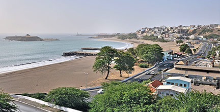
 Panorama of Chã d'Areia, Praia's Gamboa beach front seen from Plateau. Image: Reino Baptista |
About PraiaThe Portuguese discovered the uninhabited islands in the 15th century and soon colonized it. The first Portuguese settlers arrived in 1462 and founded Ribeira Grande on the island of Santo Antão, the oldest European settlement in the tropics. Praia is located on the southern coast of Santiago island, it has a population of 130,000 inhabitants (in 2010). The city is Cape Verde’s commercial center, and is home to the University of Cape Verde. Spoken languages are Portuguese (official) and Kabuverdianu (Portuguese based Cape Verdean Creole). The map shows a city map of Praia with expressways, main roads and streets, and the location of Praia International Airport (IATA code: RAI) about 3 km (2 mi) northeast of central Praia. To find a location use the form below. |
|
| To find a location type: street or place, city, optional: state, country. |
Local Time Cape Verde:
Tuesday-July-7 12:57
Timezone: Cape Verde Time (CVT) :: UTC/GMT -1h |
|
φ Latitude, λ Longitude (of Map center; move the map to see coordinates): , |
||||||
| Google Earth: Searchable Map and Satellite view of Praia, Cape Verde. City Coordinates: 14.918°N 23.509°W | Bookmark/share this page |
|||||
| More about Cape Verde: Country: Political Map of Cape Verde Map of Cape Verde showing the administrative divisions of Cape Verde. Continent: |
Weather Conditions Cameroon
External Links: Câmara Municipal da Praia Official website of the city of Praia. Wikipedia: Praia |
Explore more:
Related Consumer Information:
|
||||
Other Capitals in West Africa: Abidjan, Abuja, Accra, Bamako, Banjul, Bissau, Conakry, Cotonou, Dakar, Freetown, Lomé Monrovia, Niamey, Nouakchott, Ouagadougou, Porto-Novo, Yamoussoukro Searchable Maps of other Countries in West Africa: Benin | Burkina Faso | Cape Verde | Côte d'Ivoire | Gambia | Ghana | Guinea | Guinea-Bissau Liberia | Mali | Mauritania | Niger | Nigeria | Senegal | Sierra Leone | Togo |
||||||
Map Help [ show ] |
||||||
One World - Nations Online .:. let's care for this planet Promote that every nation assumes responsibility for our world. Nations Online Project is made to improve cross-cultural understanding and global awareness. More signal - less NOISE |
| Site Map
| Information Sources | Disclaimer | Copyright © 1998-2024:: nationsonline.org |