Nations Online
All Countries in the World
Nations Online All Countries in the World | |
Home  |
___ Satellite View and Map of the City of Monrovia, Liberia |
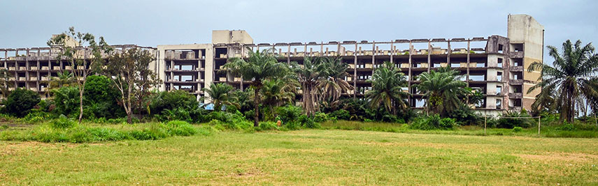 Ruins of the former five-star Hotel Africa in Monrovia. Hotel Africa was the largest Hotel in Liberia, it was built to host the conference of the Organisation of African Unity in 1979. The OAU was replaced by the African Union in 2002. The hotel was destroyed during the First Liberian Civil War (from 1989 until 1997). Image: jbdodane |
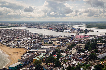
About Monrovia Satellite view is showing Monrovia, largest city, chief port and the national capital of Satellite view is showing Monrovia, largest city, chief port and the national capital of Monrovia is the cultural, political and financial center of the country and a main hub of commerce and transportation. The city has a population of about 1 million people in the Greater Monrovia District. History (short version) Founded in 1822 by the American Colonization Society as a haven for freed slaves from the United States and the British West Indies. The city was named for James Monroe, then the president of the United States. Until recently the city was still controlled by descendants of the early settlers who arrived between 1830 and 1870. Since it broke ties with the United States after 1871, it long remained an interesting cultural combination of pre– Civil War Southern American and West African influences. The city was damaged during the Liberian Civil War in the early 1990s. (from: Encyclopedia of Historic Places) The map shows a city map of Monrovia with expressways, main roads and streets, and the location of Spriggs Payne Airport (IATA code: MLW). Zoom out to find the location of Roberts International Airport (IATA code: ROB), about 60 km (40 mi) east of the city near the town of Harbel at Robertsfield. To find a location use the form below. |
|
| To find a location type: street or place, city, optional: state, country. | Local Time Liberia:
Tuesday-July-7 07:59
Time Zone: no time offset of GMT/UTC GMT/UTC 0 |
One World - Nations Online .:. let's care for this planet Promote that every nation assumes responsibility for our world. Nations Online Project is made to improve cross-cultural understanding and global awareness. More signal - less NOISE |
| Site Map
| Information Sources | Disclaimer | Copyright © 1998-2024:: nationsonline.org |