Nations Online
All Countries in the World
Nations Online All Countries in the World | |
Home  |
___ Satellite View and Map of the City of Porto-Novo, Benin |
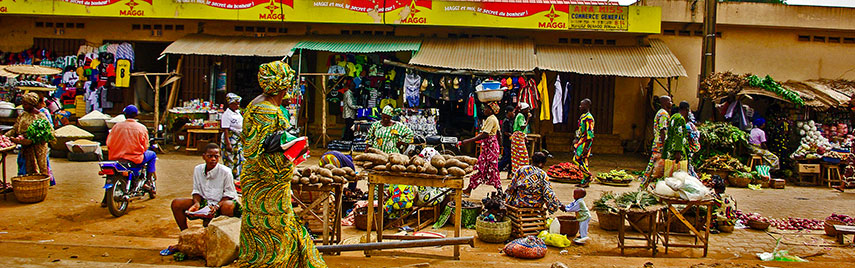 Ouando Market in Porto-Novo. Image: Babylas |
About Porto-NovoSatellite view is showing Porto-Novo (Portuguese: New Harbour), also known as Hogbonou and Adjacé. The city is located on Porto-Novo lagoon, an inlet of the Gulf of Guinea, in the southeastern corner ofThe natural harbor of Porto-Novo lagoon was a convenient location for the Portuguese to establish a trading post there in the 17th century to do business, they dealt in the profitable slave trade, providing cheap workforce for the Americas. Porto-Novo is Benin's national capital with a population of approximately 250,000 inhabitants. The city is connected by a 40 km railroad line to Cotonou, the largest city and the economic capital of Benin. Official The map shows the city of Porto-Novo with main roads, zoom out to find the location of Cotonou Cadjehoun Airport (IATA Code: COO) Benin's main airport located in southwest near Cotonou, Benin's largest city and de facto capital. To find a location use the form below. |
|
| To find a location type: street or place, city, optional: state, country. |
Local Time Benin:
Monday-July-6 23:39
UTC/GMT +1 hours |
|
φ Latitude, λ Longitude (of Map center; move the map to see coordinates): , |
||||||
| Sorry! Google's pricing policy has made it impossible for us to continue showing Google Maps. We apologize for any inconvenience. Google Map: Map of the City of Porto-Novo, Benin. City Coordinates: 6°29′50″N 2°36′18″E |
Bookmark/share this page |
|||||
| More about Benin: Cities: Country: Continent: External Links Wikipedia: Porto-Novo |
Current Weather Conditions Cotonou Weather station at Cotonou Cadjehoun Airport.
|
Explore More:
Related Consumer Information:
|
||||
Other Capital Cities in West Africa Abuja, Accra, Bamako, Banjul, Bissau, Conakry, Dakar, Freetown, Lomé, Monrovia, Niamey, Nouakchott, Ouagadougou, Praia, Yamoussoukro Searchable Maps of other Countries in West Africa: Burkina Faso | Cape Verde | Côte d'Ivoire | Gambia | Ghana | Guinea | Guinea-Bissau Liberia | Mali | Mauritania | Niger | Nigeria | Senegal | Sierra Leone | Togo |
||||||
Map Help [ show ] |
||||||
One World - Nations Online .:. let's care for this planet Promote that every nation assumes responsibility for our world. Nations Online Project is made to improve cross-cultural understanding and global awareness. More signal - less NOISE |
| Site Map
| Information Sources | Disclaimer | Copyright © 1998-2024:: nationsonline.org |