Nations Online
All Countries in the World
|
One Planet Nations Online All Countries in the World | |
Home  |
___ Satellite View and Map of the City of Banjul, The Gambia |
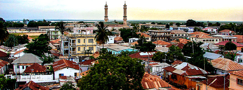
 Banjul with King Fahad Mosque in center (King Fahd of Saudi Arabia, Custodian of the Two Holy Mosques (not this one), was the King of Saudi Arabia from 1982 to 2005). Image: Bjørn Christian Tørrissen |
About BanjulSatellite view is showing Banjul (until 1973 known as Bathurst), the capital ofThe smallest country on mainland Africa has an area of 11,295 km², it is about the size of one third of Belgium or slightly less than twice the size of Delaware. The country is surrounded completely by Senegal. In the beginning of the 19th century, the British, who ruled slave trade illegal in 1807, established Bathurst on St. Mary island (Banjul island) to combat the trade of African slaves (before that time they were themselve profoundly involved in the trade). Banjul is located just 14 km east of the country's largest city Serrekunda (Sara Job Kunda) on Banjul Island (or St. Mary's Island) on the Gambia River estuary to the Atlantic Ocean. The port city has a core population of about 35,000 inhabitants, but more than 500,000 live in its metropolitan area. The majority of the people are Muslims (90%). Spoken languages are English (official), Mandinka, Fula, Wolof and other West-African languages. The City of Banjul is the administrative, economic, and transport center of the nation, and is home to the Central Bank of the Gambia. Attractions for visitors are the Gambia National Museum, Arch 22, the distinctive gateway to Gambia's capital, and there is Albert Market, a big traditionel Gambian market. 12 km west of Banjul lies Bakau a seaside resort at the Atlantic Ocean with beaches at Cape Point, the town is known for its botanical gardens and for the sacred crocodile pool of Bakau Kachikally. The map shows a city map of Banjul with expressways, main roads and streets, zoom out to find the location of Banjul International Airport (Yundum International) (IATA code: BJL) about 26 km (16 mi) southwest of the city center. To find a location use the form below. |
|
| To find a location type: street or place, city, optional: state, country. |
Local Time The Gambia:
Thursday-April-25 10:18
West Africa Time (WAT): UTC/GMT +1 h |
One World - Nations Online .:. let's care for this planet Promote that every nation assumes responsibility for our world. Nations Online Project is made to improve cross-cultural understanding and global awareness. More signal - less NOISE |
| Site Map
| Information Sources | Disclaimer | Copyright © 1998-2023 :: nationsonline.org |