Nations Online
All Countries in the World
Nations Online All Countries in the World | |
Home  |
___ Satellite View and Map of the City of Port-au-Prince (Pòtoprens), Haiti |
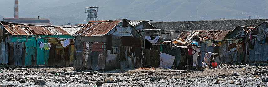 Cité Soleil (sun city) a slum area in Port-au-Prince, the shacks are built on a rubbish dump. Image: Thomas Black |
About Port-au-PrinceSatellite view is showing Port-au-Prince, chief port, largest city and the national capital of an impoverishedOn 12 January 2010 a 7.0 magnitude earthquake struck Haiti, many aftershocks followed and left the Haitian capital in a shambles and half of the city's population displaced. Port-au-Prince has a population of estimated 1.2 million inhabitants and more than 2.5 to 3 million live in its metropolitan area, including the rapid growing slums on the hillsides above the city, like the neighborhoods of Carrefour, Martissant, Bel Air, or Cité Soleil , an extremely impoverished and densely populated commune built on a rubbish dump, originally developed as a shanty town, it grew to a slum with estimated 200,000 to 400,000 residents. And the slums of the capital will grow larger, if neighboring Dominican Republic begins enforcing new legislation which deports any foreign-born worker, most of them Haitians, hundreds of thousands of migrant workers now face deportation. The map shows a city map of Port-au-Prince with expressways, main roads and streets, and the location of Toussaint Louverture International Airport (IATA code: PAP). To find a location use the form below. |
|
| To find a location type: street or place, city, optional: state, country. |
Local Time Port-au-Prince:
Saturday-July-4 2026 09:17
Time zone: Eastern Standard Time (EST) UTC/GMT -5 hoursEastern Daylight Time (EDT) UTC/GMT -4 hours (mid March - beginning November) |
One World - Nations Online .:. let's care for this planet Promote that every nation assumes responsibility for our world. Nations Online Project is made to improve cross-cultural understanding and global awareness. More signal - less NOISE |
| Site Map
| Information Sources | Disclaimer | Copyright © 1998-2024:: nationsonline.org |

