Nations Online
All Countries in the World
Nations Online All Countries in the World | |
Home  |
___ Satellite View and Map of the City of Fort-de-France, Martinique |
About Fort-de-France Satellite view is showing Fort-de-France, territorial capital of the French overseas department (département d'outre-mer) of Satellite view is showing Fort-de-France, territorial capital of the French overseas department (département d'outre-mer) of The city is located at the coast of Fort-de-France Bay, at the mouth of Madame River. Fort-de-France has a city population of about 94,000 inhabitants and 135,000 live in its urban area. Official language is French, many inhabitants of Martinique also speak Antillean Creole. Some points of interest: La Savane (Jardin du Roi; park), Jardin de Balata (botanical garden), Schoelcher Library (books), Fort St. Louis (fort and naval base), St. Louis Cathedral, Musee Departemental de la Martinique (museum), Musee Regional D'histoire et D'ethnographie (history museum), Les Grands Ballets Martiniquais (folkloric performance). Just zoom in (+) to see the harbor of Fort-de-France with its cruise ship terminal. The map shows a city map of Fort-de-France with expressways, main roads and streets, and the location of Martinique Aimé Césaire International Airport/Lamentin Airport (IATA code: FDF) in east. To find a location use the form below. |
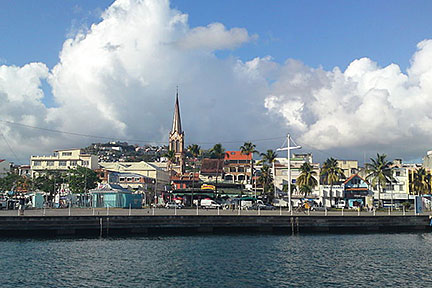 Fort-de-France with St. Louis Cathedral in center, Martinique. Image: Jean-Louis Lascoux Bookmark/share this page |
| To find a location type: street or place, city, optional: state, country. |
Martinique actual time:
Thu-Apr-25 01:42
Time zone: Atlantic Standard Time (AST) :: GMT (UTC): - 4h |
One World - Nations Online .:. let's care for this planet Promote that every nation assumes responsibility for our world. Nations Online Project is made to improve cross-cultural understanding and global awareness. More signal - less NOISE |
| Site Map
| Information Sources | Disclaimer | Copyright © 1998-2023 :: nationsonline.org |

