Nations Online
All Countries in the World
Nations Online All Countries in the World | |
Home  |
___ Satellite View and Map of the City of Kingstown, Saint Vincent and the Grenadines |
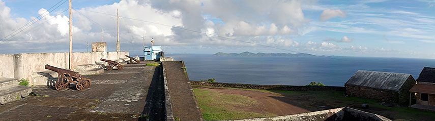 Fort Charlotte, the historic fort was built in 1806, Kingstown, Saint Vincent and the Grenadines. Image: Sebb |
About KingstownSatellite view is showing Kingstown, chief port and the national capital ofKingstown is the commercial center of the archipelago, it has a population of about 25,000 inhabitants. Official language is English. Some points of interest: Botanic Gardens St. Vincent (the oldest botanic garden in the Western Hemisphere), Montreal Gardens (more botanic gardens), Cathedral of the Assumption, Fort Charlotte (fortification and barracks from 1806), La Soufrière (active volcano), Mesopotamia/Marriaqua Valley (nature hiking), Bequia (island), Trinity Falls (waterfall), Owia Salt Pond (natural pool), Canouan (island with a barrier reef ), Tobago Cays (marine park). Nightlife in the city is centred around the hotels, restaurants and bars in downtown. The map shows a city map of Kingstown with expressways, main roads and streets, and the location of E. T. Joshua Airport (IATA code: SVD). To find a location use the form below. To view just the map, click on the "Map" button. |
|
| To find a location type: street or place, city, optional: state, country. |
Local Time Saint Vincent and the Grenadines:
Friday-April-26 03:42
Time zone: Atlantic Standard Time (AST); UTC/GMT -4 hours. |
One World - Nations Online .:. let's care for this planet Promote that every nation assumes responsibility for our world. Nations Online Project is made to improve cross-cultural understanding and global awareness. More signal - less NOISE |
| Site Map
| Information Sources | Disclaimer | Copyright © 1998-2023 :: nationsonline.org |

