Nations Online
All Countries in the World
Nations Online All Countries in the World | |
Home  |
___ Satellite View of and Map of the City of Montréal, Quebec, Canada |
 Satellite view is showing Montreal (in French: Montréal), largest city in the province of Quebec and second largest city of 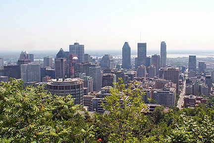 View of downtown Montreal, province of Quebec. In 2010 the Canadian Grand Prix has been held again on Île Notre-Dame in Montreal. Just zoom in to see Saint Joseph's Oratory, the largest church in Canada. The Map shows a city map of Montréal with expressways, main roads and streets, Pierre Elliott Trudeau International Airport (IATA Code: YUL) in southwest. Zoom out to find the location of Mirabel International Airport (IATA Code: YMX) about 39 km (24 mi) northwest of Montréal. To find a location use the form below. To view just the map, click on the "Map" button. |
|
| To find a location type: street or place, city, optional: state, country. |
Local Time Montreal:
Tuesday-July-14 2026 10:50
Standard time zone Eastern (EST): UTC/GMT -5 hoursDaylight Saving Time (EDT) in use from the first Sunday in March, ends on the first Sunday in November; time zone offset: UTC/GMT -4 hours |
|
φ Latitude, λ Longitude (of Map center; move the map to see coordinates): , |
||||||
| Sorry! Google's pricing policy has made it impossible for us to continue showing Google Maps. We apologize for any inconvenience. Google Map: Searchable map/satellite view of Montreal, Canada. Coordinates: 45°30′N 73°40′W |
Bookmark/share this page |
|||||
| More about Canada: Cities: Other major Cities of Canada: Country: Canada key statistical figures. Continent: |
Weather Conditions Montreal
External Links: Ville de Montréal Montreal's official city portal site. Montréal Montreal's official tourism web site. Wikipedia: Montréal Wikipedia article about Montreal. |
Related Consumer Information:
|
||||
Major U.S. Cities: Atlanta, Atlantic City, Austin, Baltimore, Boston, Charlotte, Chicago, Cincinnati, Cleveland, Columbus, Dallas, Denver, Detroit, El Paso, Fort Worth, Honolulu, Houston, Indianapolis, Jacksonville, Kansas City, Las Vegas, Long Beach, Los Angeles, Memphis, Miami, Milwaukee, Minneapolis, Nashville, New Orleans, New York City, Norfolk, Oklahoma City, Orlando, Philadelphia, Phoenix, Pittsburgh, Portland, Sacramento, St. Louis, San Antonio, San Diego, San Francisco, San Jose, Santa Fe, Seattle, Tampa, Tucson, Washington D.C. |
||
Map Help [ show ] |
||
One World - Nations Online .:. let's care for this planet Promote that every nation assumes responsibility for our world. Nations Online Project is made to improve cross-cultural understanding and global awareness. More signal - less NOISE |
| Site Map
| Information Sources | Disclaimer | Copyright © 1998-2024:: nationsonline.org |

