Nations Online
All Countries in the World
Nations Online All Countries in the World | |
Home  |
___ Satellite View and map of Quebec City (Ville de Québec) |
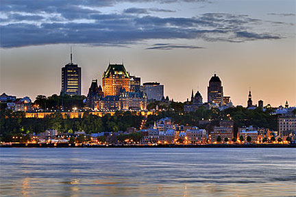
 Satellite view is showing Quebéc City, the capital of the Canadian province of Quebec, the city is located on the north bank of the St. Lawrence river, opposite Lévis on the south bank. Satellite view is showing Quebéc City, the capital of the Canadian province of Quebec, the city is located on the north bank of the St. Lawrence river, opposite Lévis on the south bank. The city is the Heart of French Canada and is on Money Magazine's list of North America's top ten tourist destinations. Quebéc has a population of 520,000 people (2011 census), predominant language is French. Just zoom in (+) to see Old Québec, the Historic District of Old Québec, a UNESCO World Heritage Site. The Map shows a city map of Québec with expressways, main roads and streets, Jean Lesage International Airport (IATA Code: YQB) in west. To find a location use the form below. To see just the map click on the "Map" Button. |
|
| To find a location type: street or place, city, optional: state, country. |
Local Time Quebéc:
Tuesday-April-16 2024 09:54
Standard time zone Eastern (EST): UTC/GMT -5 hoursDaylight Saving Time (EDT) in use from the second Sunday in March, ends on the first Sunday in November; time zone offset: UTC/GMT -4 hours |
|
φ Latitude, λ Longitude (of Map center; move the map to see coordinates): , |
||||||
| Sorry! Google's pricing policy has made it impossible for us to continue showing Google Maps. We apologize for any inconvenience. Google Map: Searchable map/satellite view of Quebéc, Quebec province, Canada. City Coordinates: 46°49′N 71°13′W |
Bookmark/share this page |
|||||
| More about Canada: Cities: Satellite view and maps of other major Cities of Canada: Country: Canada key statistical figures. Continent: |
Current Weather Conditions Quebéc Weather station in L'Ancienne-Lorette, Quebéc
External Links: Ville de Québec Official website of the City of Québec. Wikipedia: Quebéc Wikipedia article about Quebéc. |
Related Consumer Information:
|
||||
Major U.S. Cities: Atlanta, Atlantic City, Austin, Baltimore, Boston, Charlotte, Chicago, Cincinnati, Cleveland, Columbus, Dallas, Denver, Detroit, El Paso, Fort Worth, Honolulu, Houston, Indianapolis, Jacksonville, Kansas City, Las Vegas, Long Beach, Los Angeles, Memphis, Miami, Milwaukee, Minneapolis, Nashville, New Orleans, New York City, Norfolk, Oklahoma City, Orlando, Philadelphia, Phoenix, Pittsburgh, Portland, Sacramento, St. Louis, San Antonio, San Diego, San Francisco, San Jose, Santa Fe, Seattle, Tampa, Tucson, Washington D.C. |
||
Map Help [ show ] |
||
One World - Nations Online .:. let's care for this planet Promote that every nation assumes responsibility for our world. Nations Online Project is made to improve cross-cultural understanding and global awareness. More signal - less NOISE |
| Site Map
| Information Sources | Disclaimer | Copyright © 1998-2023 :: nationsonline.org |