Nations Online
All Countries in the World
Nations Online All Countries in the World | |
Home  |
___ Satellite View and Map of the City of Paramaribo, Suriname |
About ParamariboSatellite view is showing Paramaribo, largest city, chief port and the national capital ofThe district of Paramaribo is the most populated place in Suriname and is characterized by its historical heritage. The city was a former Dutch colonial town (from the 17th until the 18th centuries). The original and highly distinctive street plan of the historic center remains intact. Today the Historic Inner City of Paramaribo is a UNESCO World Heritage Site. The city is home to Fort Zeelandia, a fortress built by British colonists in 1651. Other buildings and landmarks are St. Peter and Paul Cathedral, the Presidential Palace, the Ministry of Finance, the Court of Justice, the Waterfront with the Central Market, the Palm Garden, the Independence Square, and two cinemas, until now, the only motion-picture theaters in the country. Paramaribo has a population of less than 245,000 inhabitants (2012). Official language is Dutch. The map shows a city map of Paramaribo with expressways, main roads and streets. Zoom out to find the location of Paramaribo-Zanderij International Airport (IATA code: PBM) about 45 km (28 mi) south of the city. To find a location use the form below. |
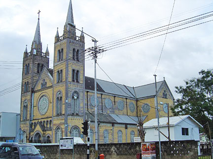 St. Peter and Paul Cathedral, a wooden Roman Catholic church, the biggest wooden structure in the Western Hemisphere, located in the center of Paramaribo. Image: © UNESCO, Ron Van Oers Bookmark/share this page |
| To find a location type: street or place, city, optional: state, country. |
Local Time Suriname:
Tuesday-June-30 08:29
Standard time zone: Suriname Time (SRT) UTC/GMT -3 hours |
|
φ Latitude, λ Longitude (of Map center; move the map to see coordinates): , |
||||||
| Google Earth: Searchable Map and Satellite view of Paramaribo, Suriname. |
||||||
| More about Suriname: Country: Continent: Historically related Countries: External Links Wikipedia: Paramaribo |
Current Weather Conditions Paramaribo, weather station is at the International Airport near Zanderij.
|
Related Consumer Information:
|
||||
Other Cities in South America: Asunción (Paraguay) - Bogotá D.C. (Colombia) - Brasilia, Rio de Janeiro, São Paulo, Salvador, (all Brazil) - Buenos Aires (Argentina) - Caracas (Venezuela) - Cayenne, Kourou (both French Guiana) - Georgetown (Guyana) - La Paz, Sucre (both Bolivia) - Lima (Peru) - Montevideo (Uruguay) - Port of Spain (Trinidad and Tobago) - Quito (Ecuador) - Santiago (Chile) |
||
Map Help [ show ] |
||
One World - Nations Online .:. let's care for this planet Promote that every nation assumes responsibility for our world. Nations Online Project is made to improve cross-cultural understanding and global awareness. More signal - less NOISE |
| Site Map
| Information Sources | Disclaimer | Copyright © 1998-2024:: nationsonline.org |

