Nations Online
All Countries in the World
Nations Online All Countries in the World | |
Home  |
___ Satellite View and Map of the City of Quito (San Francisco de Quito), Ecuador |
 Panorama of Quito, Cotopaxi volcano in background. Image: Carlos Rodríguez/Andes |
About Quito Satellite view is showing San Francisco de Quito, second most populous city and the national capital of Satellite view is showing San Francisco de Quito, second most populous city and the national capital of  View from Quito's historic center along Calle Garcia Moreno, El Panecillo hill in background. Image: Cayambe Quito lies at an altitude of 2,850 m (9,350 ft.), making it the second highest capital in the world only surpassed by La Paz in Bolivia. The city has a population of about 1.5 million inhabitants. Official language is Spanish. The Historic Center of Quito is a UNESCO World Cultural Heritage Site. It is one of the largest, least-altered and best-preserved historic centers in the Americas. The monasteries of San Francisco and Santo Domingo, and the Church and Jesuit College of La Compañía, with their rich interiors, are pure examples of the 'Baroque school of Quito', which is a fusion of Spanish, Italian, Moorish, Flemish and indigenous art. 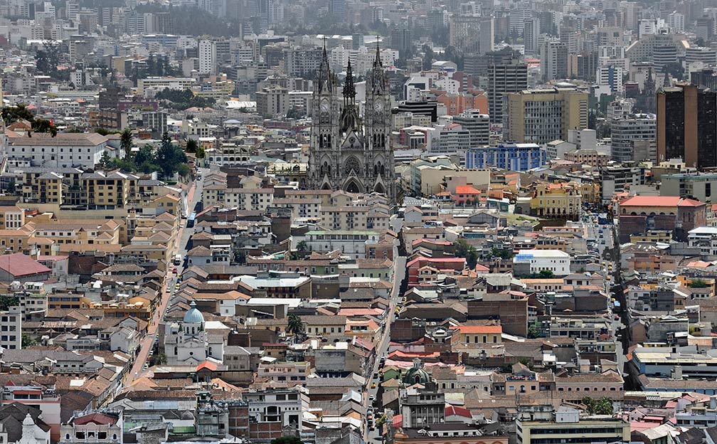 View of the historic centre of the city, as seen from El Panecillo, with Basílica del Voto Nacional in the center. Image: Cayambe Outside Quito: Pululahua Geobotanical Reserve with Pululuhua Volcano and Cotopaxi National Park with Cotopaxi volcano. The map shows a city map of Quito with expressways, main roads and streets, and the location of Mariscal Sucre International Airport (IATA code: UIO) in the Tababela parish, 36 km (23 mi) by road (via Ruta Collas) east of the city center. To find a location use the form below. |
|
| To find a location type: street or place, city, optional: state, country. |
Local Time Quito:
Sunday-April-28 12:07
UTC/GMT -5 hours
|
|
φ Latitude, λ Longitude (of Map center; move the map to see coordinates): , |
||||||
| Google Maps: Searchable map/satellite view of Quito, Ecuador. Coordinates: 00°15′00″S 78°35′00″W |
Bookmark/share this page |
|||||
| More about Ecuador: Cities: Country: Key statistic figures Ecuador. Continent: |
Weather Conditions Quito
External Links: Quito (official web site) City of Quito - UNESCO World Heritage Wikipedia: Quito |
Related Consumer Information:
|
||||
Other Cities in South America: Asunción (Paraguay) - Bogotá D.C. (Colombia) - Brasilia, Rio de Janeiro, São Paulo, Salvador, (all Brazil) Buenos Aires (Argentina) - Caracas (Venezuela) - Cayenne, Kourou (both French Guiana) - Georgetown (Guyana) La Paz, Sucre (both Bolivia) - Lima (Peru) - Montevideo (Uruguay) - Paramaribo (Suriname) Port of Spain (Trinidad and Tobago) - Santiago (Chile) |
||
Map Help [ show ] |
||
One World - Nations Online .:. let's care for this planet Promote that every nation assumes responsibility for our world. Nations Online Project is made to improve cross-cultural understanding and global awareness. More signal - less NOISE |
| Site Map
| Information Sources | Disclaimer | Copyright © 1998-2023 :: nationsonline.org |

