Nations Online
All Countries in the World
Nations Online All Countries in the World | |
Home  |
___ Satellite View and Map of Guiana Space Center, Kourou, French Guiana |
About Europe's Spaceport in Kourou Europe's Spaceport is situated in the northeast of South America in Europe's Spaceport is situated in the northeast of South America in Surrounded on two sides by equatorial forest, to the east it has a 50 km coastline bordering the Atlantic Ocean and to the south lies the town of Kourou. The Spaceport contains the administrative buildings, the Jupiter Control Centre (CDC), as well as the numerous facilities required for a launch. Satellite view shows the facilities of Guiana Space Center (in French: Centre Spatial Guyanais). The European spaceport is operational since 1968. In 1964 the French Government chose Kourou, from 14 other sites, as a base from which to launch its satellites. The location for the spaceport fulfills two major geographical requirements, it is quite close to the equator, so that the spinning earth can impart some extra velocity to the rockets, and it has uninhabited territory, French Guiana is scarcely populated and 90% of the country is covered by equatorial forests. In addition there is no risk of cyclones or earthquakes, because the tracks of cyclones are more to the north, and the whole region is situated on the Guiana Shield, an old and stable part of the continental lithosphere. To find a location use the form below. |
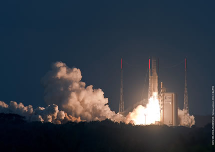 Arianespace's 51st consecutive heavy-lift success with Ariane 5 orbited the ASTRA 2F and GSAT-10 satellites during an on-target mission from the Spaceport in French Guiana. Image: courtesy of © 2012 ESA-CNES-Arianespace Bookmark/share this page |
| To find a location type: street or place, city, optional: state, country. |
Local Time French Guiana:
Thursday-May-2 17:44
Standard time zone: French Guiana Time (GFT) UTC/GMT -3 hours |
|
φ Latitude, λ Longitude (of Map center; move the map to see coordinates): , |
||||||
| Google Earth: Map and Satellite view of the ESA Space Center, Kourou, French Guiana. |
||||||
| More about French Guiana: Cities: Country: Continent: Historically related Countries: |
Current Weather Conditions Cayenne
External Links ESA Space Center (Official website) Wikipedia: Kourou |
Related Consumer Information:
|
||||
| Other Cities in South America: Asunción (Paraguay) - Bogotá D.C. (Colombia) - Brasilia, Rio de Janeiro, São Paulo, Salvador, (all Brazil) - Buenos Aires (Argentina) - Caracas (Venezuela) - Georgetown (Guyana) - La Paz, Sucre (both Bolivia) - Lima (Peru) - Montevideo (Uruguay) - Paramaribo (Suriname) - Port of Spain (Trinidad and Tobago) - Quito (Ecuador) - Santiago (Chile) |
||
Map Help [ show ] |
One World - Nations Online .:. let's care for this planet Promote that every nation assumes responsibility for our world. Nations Online Project is made to improve cross-cultural understanding and global awareness. More signal - less NOISE |
| Site Map
| Information Sources | Disclaimer | Copyright © 1998-2023 :: nationsonline.org |

