Nations Online
All Countries in the World
Nations Online All Countries in the World | |
Home  |
___ Satellite View and Map of the City of Sucre, Bolivia |
About Sucre Satellite view is showing Sucre, the constitutional capital of Satellite view is showing Sucre, the constitutional capital of The city is situated in the south-central part of the country and lies at an altitude of 2750 m, making it the number three of the worlds capital with the highest elevation, only surpassed by Ecuador's capital Quito (2850 m) and La Paz (3640 m), the seat of Bolivia's government. Sucre has a population of about 250,000 inhabitants. Official language is Spanish. The Historic City of Sucre is a UNESCO World Heritage Site, the first capital of Bolivia was founded by the Spanish in the first half of the 16th century. Its many well-preserved 16th-century religious buildings, such as San Lázaro, San Francisco and Santo Domingo, illustrate the blending of local architectural traditions with styles imported from Europe. The map shows a city map of Sucre with expressways, main roads and streets, zoom out to find the location of Juana Azurduy de Padilla International Airport (IATA code: SRE). To find a location use the form below. |
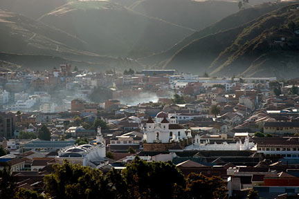 Historic City of Sucre is a UNESCO World Heritage Site Image: Alessandro Muiesan Bookmark/share this page |
| To find a location type: street or place, city, optional: state, country. |
Local Time Bolivia:
Sunday-July-26 16:54
UTC/GMT -4 hours |
|
φ Latitude, λ Longitude (of Map center; move the map to see coordinates): , |
||||||
| Google Earth: Searchable Map and Satellite view of Sucre, Bolivia. |
||||||
| Coordinates: 19°2′2″S 65°15′45″W |
||||||
| More about Bolivia: Country: Bolivia statistical key figures. Continent: External Link Sucre (official web site; in Spanish) Wikipedia: Sucre |
Current Weather Conditions Sucre
|
Related Consumer Information:
|
||||
Other Cities in South America: Asunción (Paraguay) - Bogotá D.C. (Colombia) - Brasilia, Rio de Janeiro, São Paulo, Salvador, (all Brazil) - Buenos Aires (Argentina) - Caracas (Venezuela) - Cayenne, Kourou (both French Guiana) - Georgetown (Guyana) - Lima (Peru) - Montevideo (Uruguay) - Paramaribo (Suriname) - Port of Spain (Trinidad and Tobago) - Quito (Ecuador) - Santiago (Chile) |
||
Map Help [ show ] |
||
One World - Nations Online .:. let's care for this planet Promote that every nation assumes responsibility for our world. Nations Online Project is made to improve cross-cultural understanding and global awareness. More signal - less NOISE |
| Site Map
| Information Sources | Disclaimer | Copyright © 1998-2024:: nationsonline.org |

