Nations Online
All Countries in the World
Nations Online All Countries in the World | |
Home  |
___ Satellite View and Map of the City of La Paz, Bolivia |
About La Paz Satellite view is showing La Paz, Satellite view is showing La Paz, La Paz is the highest capital city in the world at an altitude of 3,660 m (12,000 ft). The city is situated at the foothills of the Cordillera Real (part of the Andes) between the Illimani mountain (6,438 m) and Lake Titicaca. Nuestra Señora de La Paz (the city's official Spanish name) has a population of about 770,000 inhabitants (2012 census), more than 2 million people live in the metropolitan area. Official language is Spanish. The map shows a city map of La Paz with expressways, main roads and streets, and the location of El Alto International Airport (IATA code: LPB) in the satellite city of El Alto. To find a location use the form below. |
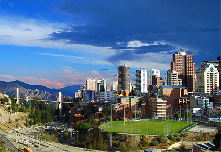 View of La Paz from Avenida del Ejército with the Puente de Las Americas (Bridge of the Americas) in background. Image: Donvittore Bookmark/share this page |
| To find a location type: street or place, city, optional: state, country. |
Local Time Bolivia:
Saturday-April-27 12:01
UTC/GMT -4 hours
|
|
φ Latitude, λ Longitude (of Map center; move the map to see coordinates): , |
||||||
| Google Maps: Searchable map/satellite view of La Paz, Bolivia. |
||||||
| Coordinates: 16°30′S 68°09′W |
||||||
| More about Bolivia: Cities: Country: Bolivia statistical key figures. Continent: External Link La Paz (official web site; in Spanish) Wikipedia: La Paz |
Current Weather Conditions La Paz
|
Related Consumer Information:
|
||||
Other Cities in South America: Asunción (Paraguay) - Bogotá D.C. (Colombia) - Brasilia, Rio de Janeiro, São Paulo, Salvador, (all Brazil) - Buenos Aires (Argentina) - Caracas (Venezuela) - Cayenne, Kourou (both French Guiana) - Georgetown (Guyana) - Lima (Peru) - Montevideo (Uruguay) - Paramaribo (Suriname) - Port of Spain (Trinidad and Tobago) - Quito (Ecuador) - Santiago (Chile) |
||
Map Help [ show ] |
||
One World - Nations Online .:. let's care for this planet Promote that every nation assumes responsibility for our world. Nations Online Project is made to improve cross-cultural understanding and global awareness. More signal - less NOISE |
| Site Map
| Information Sources | Disclaimer | Copyright © 1998-2023 :: nationsonline.org |

