Nations Online
All Countries in the World
|
One Planet Nations Online All Countries in the World | |
 |
___ Satellite View and Map of the City of Mecca (Makkah al-Mukarramah), Saudi Arabia |
 Panorama view of Masjid al-Haram, the "Sacred Mosque", it is the largest mosque in the world. Masjid al-Haram surrounds Islam's holiest place, the Kaaba, a cuboid-shaped building in the center. Muslims around the world turn toward Kaaba while performing salah (prayer). Image: Bluemangoa |
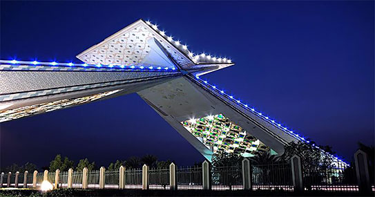
About MeccaThe map shows Mecca the holy city of Islam in Quran Gate, the entry gate of Mecca on Jeddah Makkah Highway. Image: Rowan5j Masjid al-Haram, the sacred mosque, Kaaba, Abraj Al-Bait Towers or Makkah Royal Clock Tower Hotel, a building complex in the center of Mecca, its tallest tower is the tallest building in Saudi Arabia with a height of 601 m. Jabal al-Nour, the "Mountain of Light", the mountain houses the Ghar Hira, a gap in the mountain, the location where in Muslim believe Muhammad received the first verses of the Quran from God through the angel Jebril (Gabriel). Mecca is considered by Muslims to be the holiest city of Islam. To visit Mecca you have to be a Muslim, non-Muslims are strictly prohibited to enter the city. Hajj pilgrims travel constantly between Mecca and Mina (also known as the Tent City), in the Jamarat Area is the site of the symbolic stoning of the Devil. Muzdalifah, the desert where the pilgrims spend the night. Mount Arafat, the Mount of Mercy in the Uranah valley near Mecca, in Islamic tradition, the hill is the place where the prophet Muhammad delivered the Farewell Sermon, Zoom in to see the holy mosque center with the Ka'bah (Kaabah), the holiest place in Islam. The map shows a city map of Mecca with expressways, main roads and streets. Mecca’s small Mecca East Airport has no airline service, so most pilgrims access the city through the Hajj terminal of King Abdulaziz International Airport (IATA code: JED) located 19 km (12 mi) north of the city of Jeddah, about 80 km (50 mi) west of Mecca. To find a location use the form below. |
|
| To find a location type: street or place, city, optional: state, country. |
Local Time Mecca:
Monday-April-22 07:06
UTC/GMT +3 hours |
|
, |
||||||
| Google Earth: Searchable Map and Satellite view of Mecca (Makkah), Saudi Arabia. City Coordinates: 21°25′0″N 39°49′0″E |
Bookmark/share this page
|
|||||
| More about Saudi Arabia: Cities: Country: Saudi Arabia key statistical data. Continent: External Links: Ministry of Haj Wikipedia: Mecca |
Current Weather Conditions Mecca: |
Related Consumer Information:
|
||||
Searchable Maps of Cities in the Middle East Region: Abu Dhabi | Aden | Alexandria | Amman | Ankara | Baghdad | Baku | Beirut | Damascus | Doha | Dubai (City) Jerusalem | Kuwait (City) | Luxor | Manama | Mecca | Muscat | Nazareth | Nicosia | Port Said | Riyadh Sanaa | Sharm el-Sheikh | Suez | Tehran | Tel Aviv |
||||||
Map Help [ show ]  |
||||||
One World - Nations Online .:. let's care for this planet Promote that every nation assumes responsibility for our world. Nations Online Project is made to improve cross-cultural understanding and global awareness. More signal - less NOISE |
| Site Map
| Information Sources | Disclaimer | Copyright © 1998-2023 :: nationsonline.org |