Nations Online
All Countries in the World
Nations Online All Countries in the World | |
Home  |
___ Satellite View of Faroe Islands (Føroyar) |
Searchable Map and Satellite View of Faroe Islands using Google Earth Data
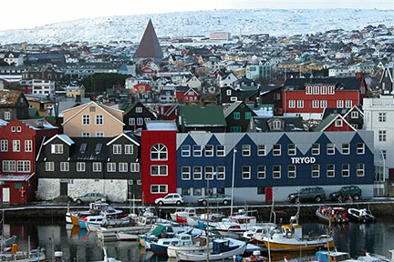 Harbor of Tórshavn Photo: Erik Christensen Territorial capital is Tórshavn. The Faroe Islands are Part of the Kingdom of Denmark. Related countries: Iceland, Norway, United Kingdom. The map shows Faroe Islands with cities, towns, expressways, main roads and streets, Vágar Airport (IATA code: FAE) is located on Vágar island. To find a location use the form below. To view just the map, click on the "Map" button. |
|
| To find a location type: street or place, city, optional: state, country. |
Local Time Faroe Islands:
Wednsday-April-24 13:12
Time zone Western European Time (WET) UTC+0Summer Time beginning end of March until end of October WEST (UTC+1) |
One World - Nations Online .:. let's care for this planet Promote that every nation assumes responsibility for our world. Nations Online Project is made to improve cross-cultural understanding and global awareness. More signal - less NOISE |
| Site Map
| Information Sources | Disclaimer | Copyright © 1998-2023 :: nationsonline.org |

