Nations Online
All Countries in the World
Nations Online All Countries in the World | |
Home  |
___ Map and Satellite View of Ireland (Éire) |
About Ireland
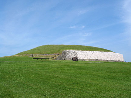 Newgrange is a prehistoric monument in County Meath, Ireland, near the River Boyne. It was built about 3200 BC, it is a UNESCO World Heritage Site Image: Richard Gallagher About four fifths of the area of Ireland are national territory of the Republic of Ireland, the remaining one fifth in the northeast of the island belongs to Northern Ireland, part of the United Kingdom (old story). With an area of 70,273 km², the Republic of Ireland is slightly larger than twice the size of Denmark, or slightly larger than the U.S. state of West Virginia. The Republic of Ireland has a population of nearly 4,8 million people (in 2018), capital city is Dublin. Spoken languages are Irish (official) and English. The Map shows Ireland with cities, expressways, main roads and streets. To find a location in Ireland use the form below. |
|
| To find a location type: street or place, city, optional: state, country. |
Local Time Ireland:
Thursday-April-25 13:07
Standard time zone GMT: No UTC/GMT offsetDaylight saving time (BST) in use from end of March until end of October, time zone offset: UTC/GMT +1 hours |
|
φ Latitude, λ Longitude (of Map center; move the map to see coordinates): , |
||||||
| Sorry! Google's pricing policy has made it impossible for us to continue showing Google Maps. We apologize for any inconvenience. Google Map: Searchable map/satellite view of the Republic of Ireland. |
||||||
| More about Ireland: Republic of Ireland: Cities: Country: Northern Ireland: Continent: |
Dublin Current Weather Conditions:
|
Related Consumer Information:
|
||||
Major Cities in Northern Europe Belfast | Birmingham | Cardiff | Copenhagen | Dublin | Edinburgh | Glasgow | Helsinki | Liverpool | London | Malmö Manchester | Nuuk | Oslo | Reykjavik | Riga | Saint Petersburg | Stockholm | Tallinn | Vilnius Maps of other Countries in Northern Europe Denmark Map, Estonia Map, Faroe Islands Map, Greenland Map, Iceland Map, Ireland Map, Latvia Map, Lithuania Map, Sweden Map, United Kingdom Map Interactive Maps of other countries and regions in Northern Europe: Denmark Interactive Map, Faroe Islands Interactive Map, Greenland Interactive Map, Iceland Interactive Map, Ireland Interactive Map, Latvia Interactive Map, Lithuania Interactive Map, Norway Interactive Map, Scotland Interactive Map, Sweden Interactive Map, United Kingdom Interactive Map |
||||||
Map Help [ show ] |
||||||
One World - Nations Online .:. let's care for this planet Promote that every nation assumes responsibility for our world. Nations Online Project is made to improve cross-cultural understanding and global awareness. More signal - less NOISE |
| Site Map
| Information Sources | Disclaimer | Copyright © 1998-2023 :: nationsonline.org |

