Nations Online
All Countries in the World
Nations Online All Countries in the World | |
Home  |
___ Satellite View and Map of Azerbaijan |
 Mount Bazardüzü, the mountain in the Greater Caucasus range on the border between Russia and Azerbaijan is the highest peak in the country. Image: Freieck |
About Azerbaijan Satellite view is showing Azerbaijan, a former Soviet republic in southeastern Europe in the Southern Caucasus, bordering the Caspian Sea in east. The country at the crossroads of Eastern Europe and Western Asia became independent in 1991 and is now officially named Republic of Azerbaijan. The republic is bordered by Armenia, Georgia, Iran, Russia, and Turkey. Satellite view is showing Azerbaijan, a former Soviet republic in southeastern Europe in the Southern Caucasus, bordering the Caspian Sea in east. The country at the crossroads of Eastern Europe and Western Asia became independent in 1991 and is now officially named Republic of Azerbaijan. The republic is bordered by Armenia, Georgia, Iran, Russia, and Turkey. 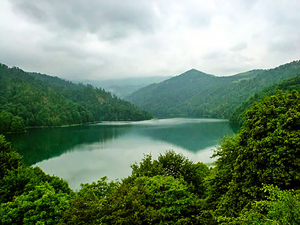 Lake Göygöl is a natural water reservoir since 1139 when huge rocks broken off Mount Kapaz in an earthquake and blocked the course of the Kürəkçay River. The lake in the Göygöl National Park near the city of Ganja is famous for its pure water. Image: Francisco Anzola Azerbaijan has a population of 9.5 million inhabitants (in 2011). Capital city is Baku. Spoken languages are Azerbaijani (official) and Russian. Main religion is Islam, about 90% of the population are Muslims. Azerbaijan's climate zones range from arid subtropical to the mountainous tundra. The country is part of an ecoregion encompassing Georgia and Armenia. Mount Kiche suv (Bazardüzü or Bazarduzu Dagi) is the highest peak in Azerbaijan with 4,466 m (14,652 ft). The country's main rivers are Kura (Kur) with a length of 1,515 km and Aras River with a length of 1,072 km. Azerbaijan economy is largely based on oil, The map shows Azerbaijan with cities, towns, expressways, and main roads. To find a location use the form below. |
|
| To find a location type: street or place, city, optional: state, country. | Local Time Azerbaijan:
Friday-April-26 00:06
Standard time zone: Azerbaijan Time (AZT) :: UTC/GMT +4, DST from end of March to end of Oct. +5 hours |
|
φ Latitude, λ Longitude (of Map center; move the map to see coordinates): , |
||||||
| Google Maps: Searchable map/Satellite View and Map of Azerbaijan. |
Bookmark/share this page |
|||||
| More about Azerbaijan: Cities: Country: Azerbaijan key statistical data. Continent: |
Current Weather Conditions Baku
|
Related Consumer Information:
|
||||
Searchable Maps of other Countries in Western Asia and Middle East: Armenia | Azerbaijan | Bahrain | Cyprus | Georgia | Iraq | Israel | Jordan | Kuwait | Lebanon | Oman | Palestinian territories | Qatar | Saudi Arabia | Syria | Turkey | United Arab Emirates | Yemen Other Capital Cities in South-Central Asia: Almaty, Ashgabat, Astana, Bishkek, Colombo, Dhaka, Dushanbe, Islamabad, Kabul, Kathmandu, Male, New Delhi, Tashkent, Tehran, Thimphu |
||||||
One World - Nations Online .:. let's care for this planet Promote that every nation assumes responsibility for our world. Nations Online Project is made to improve cross-cultural understanding and global awareness. More signal - less NOISE |
| Site Map
| Information Sources | Disclaimer | Copyright © 1998-2023 :: nationsonline.org |
