Nations Online
All Countries in the World
Nations Online All Countries in the World | |
Home  |
___ Satellite View and Map of the City of Kathmandu, Nepal |
Searchable Map of Kathmandu using Google Earth DataSatellite view is showing Kathmandu, largest city and the national capital ofKathmandu has a population of about 1.5 million inhabitants in its urban area. Official language is Nepali, and especially in Kathmandu area Nepal Bhasa (Newari). The Map shows a city map of Kathmandu with expressways, main roads and streets, Tribhuvan International Airport (IATA code: KTM) is located in east. To find a location use the form below. To see just the map click on the "Map" Button. |
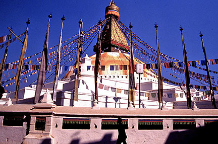 The Boudhanath stupa in Kathmandu is one of the holiest Buddhist sites in Nepal along with Swayambhunath complex. Boudhanath became a UNESCO World Heritage Site Image: Akiyoshi Bookmark/share this page |
| To find a location type: street or place, city, optional: state, country. |
Local Time Kathmandu:
Sunday-April-28 00:36
UTC/GMT +5:45 hours |
|
φ Latitude, λ Longitude (of Map center; move the map to see coordinates): , |
||||||
| Google Earth: Searchable map/satellite view of Kathmandu. |
||||||
| City Coordinates: 27°42′N 85°20′E |
||||||
| More about Nepal: Landmarks: Country: Nepal key statistical data. Continent: External Links Kathmandu (official website) Tribhuvan International Airport of Nepal Wikipedia: Kathmandu |
Current Weather Kathmandu
|
Related Consumer Information:
|
||||
| Other Cities in South-Central Asia: Almaty, Ashgabat, Astana, Baku, Bishkek, Colombo, Dhaka, Dushanbe, Islamabad Kabul, Male, New Delhi, Tashkent, Tehran, Thimphu |
||||||
Map Help [ show ] |
||||||
One World - Nations Online .:. let's care for this planet Promote that every nation assumes responsibility for our world. Nations Online Project is made to improve cross-cultural understanding and global awareness. More signal - less NOISE |
| Site Map
| Information Sources | Disclaimer | Copyright © 1998-2023 :: nationsonline.org |

