Nations Online
All Countries in the World
Nations Online All Countries in the World | |
Home  |
___ Satellite View and Map of Bolivia |
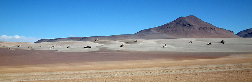 Salvador Dali Desert in southwestern Bolivia within the Eduardo Avaroa Andean Fauna National Reserve. Image: Albert Backer |
About Bolivia Map is showing Bolivia, the landlocked country in the center of South America, bordered by Argentina, Brazil, Chile, Paraguay, and Peru. The country occupies an area about twice the size of Spain, or slightly less than three times the size of the U.S. state of Montana. Map is showing Bolivia, the landlocked country in the center of South America, bordered by Argentina, Brazil, Chile, Paraguay, and Peru. The country occupies an area about twice the size of Spain, or slightly less than three times the size of the U.S. state of Montana.Bolivia's geography offers some really interesting features with three distinctive geographical regions: the tropical lowlands (llanos) covered by extensive rain forests. Then there is the transitional sub-Andean, a region of highland valleys in the south central part of Bolivia. The third region are the highlands of the Altiplano (high plateau) with Bolivia's highest peak, the snowcapped Nevado Sajama 6,542 m (21,463 ft), Lake Titicaca, the largest lake in South America; and the world's largest salt flat, Salar de Uyuni. The country is still more rural than urban, but it has the highest capital cities in the world, the administrative capital La Paz lies at an altitude of 3,640 m and Sucre, the constitutional capital (and its seat of justice), at 2750 m, only surpassed by Ecuador's capital Quito (2850 m). Both of Bolivia's capitals are situated on the Andean Plateau (Altiplano) in the western part of the country. Bolivia has a population of 11.4 million people (est. 2015). Spoken languages are Spanish (official), Aymara, Quechua, Guaraní and 34 other native languages. Other major cities are Santa Cruz de la Sierra (largest city), El Alto, Cochabamba, Oruro, Tarija, and Potosí. The map shows Bolivia with cities, towns, expressways, main roads and streets. To find a location use the form below. |
|
| To find a location type: street or place, city, optional: state, country. | Local Time Bolivia:
Thursday-April-25 08:59
UTC/GMT -4 hours
|
|
φ Latitude, λ Longitude (of Map center; move the map to see coordinates): , |
||||||
| Google Maps: Searchable map/satellite view of Bolivia. Some Points of interest: La Paz near Lake Titicaca and Valle de la Luna, with the Coca Museum, the Witches' Market, and Plaza Murillo. Illimani mountain (6,438 m), Pre-Columbian Tiwanaku, the geothermal field of Sol de Mañana, salt flat Salar de Uyuni, Amboró National Park, and Laguna Verde. |
Bookmark/share this page |
|||||
| More about Bolivia: Cities: Country: Continent: |
Current Weather Conditions La Paz
|
Related Consumer Information:
|
||||
| Searchable Maps of other Countries in South America: Argentina, Brazil, Bolivia, Chile, Colombia, Ecuador, French Guiana Guyana, Paraguay, Peru, Suriname, Uruguay, Venezuela Maps of other Countries in South America: Argentina Map, Brazil Map, Bolivia Map, Chile Map, Colombia Map, Ecuador Map, French Guiana Map, Guyana Map, Paraguay Map, Peru Map, Suriname Map, Uruguay Map, Venezuela Map Countries and Territories of The Americas |
||||||
Map Help [ show ] |
||||||
One World - Nations Online .:. let's care for this planet Promote that every nation assumes responsibility for our world. Nations Online Project is made to improve cross-cultural understanding and global awareness. More signal - less NOISE |
| Site Map
| Information Sources | Disclaimer | Copyright © 1998-2023 :: nationsonline.org |

