Nations Online
All Countries in the World
Nations Online All Countries in the World | |
Home  |
___ Satellite View and Map of the City of Brasília, Brazil |
Searchable Map and Satellite View of Brasilia Satellite view showing Brasília, since April 1960 the capital of Satellite view showing Brasília, since April 1960 the capital of 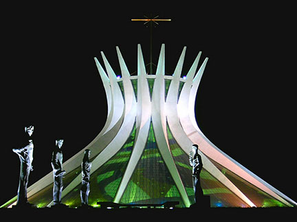 Metropolitan Cathedral in Brasília. Image: Agência Brasil, Victor Soares. Since 1987 the city is a UNESCO World Heritage Site because it is "a landmark in the history of town planning". On this page now you can walk through the city by using the "street view" option. Brasília has a population of about 2 to 2.4 million inhabitants. Official language is Portuguese. FIFA World Cup The city was one of the twelve host cities of the 2014 FIFA World Cup. Seven matches were held at the Estádio Nacional Mané Garrincha stadium. The map shows a city map of Brasília with expressways, main roads and streets, zoom out to find the location of Brasília International Airport (IATA code: BSB), named Presidente Juscelino Kubitschek International Airport. To find a location use the form below. To view the map, click on the "Map" button. |
|
| To find a location type: street or place, city, optional: state, country. |
Local Time Brasilia:
Tuesday-June-9 13:28
Brazil Standard Time: UTC/GMT -3 hoursDaylight Saving Time starts on the 3rd Sunday of October and ends on the 3rd Sunday of February shifts to UTC/GMT -2 hours. |
|
φ Latitude, λ Longitude (of Map center; move the map to see coordinates): , |
||||||
| Google Earth: Searchable Map and Satellite view of Brasília, Goiás, Brazil. City Coordinates: 15°48′S 47°54′W |
Bookmark/share this page |
|||||
| More about Brazil: Cities - background notes and a searchable map/satellite view of other Brazilian cities: Largest cities in Brazil: Other Cities: Aracaju, Belém, Boa Vista, Campo Grande, Cuiabá, Florianópolis, Goiânia, João Pessoa, Macapá, Maceió, Natal, Palmas, Porto Alegre, Porto Velho, Recife, Rio Branco, São Luís, São Paulo, Teresina, Vitória Country: Continent: External Links Brasilia (official web site) Wikipedia: Brasilia Wikipedia entry: Brasilia 2014 FIFA World Cup Official website of the Fédération Internationale de Football Association (FIFA) |
Current Weather Conditions Brasília
|
Related Consumer Information:
|
||||
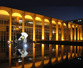 Itamaraty Palace, the Palace of Foreign Affairs in Brasilia, designed by Brazilian architect Oscar Niemeyer. Image: Xenia Antunes |
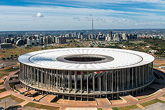 Brasilia's National Stadium Mané Garrincha Image: Brazilian Government |
|||||
Other Cities in South America: Asunción (Paraguay) - Bogotá D.C. (Colombia) - Buenos Aires (Argentina) - Caracas (Venezuela) - Cayenne, Kourou (both French Guiana) - Georgetown (Guyana) - La Paz, Sucre (both Bolivia) - Lima (Peru) - Montevideo (Uruguay) - Paramaribo (Suriname) - Port of Spain (Trinidad and Tobago) - Quito (Ecuador) - Santiago (Chile) |
||
Map Help [ show ] |
||
One World - Nations Online .:. let's care for this planet Promote that every nation assumes responsibility for our world. Nations Online Project is made to improve cross-cultural understanding and global awareness. More signal - less NOISE |
| Site Map
| Information Sources | Disclaimer | Copyright © 1998-2024:: nationsonline.org |

