Nations Online
All Countries in the World
Nations Online All Countries in the World | |
Home  |
___ Satellite View and Map of the City of Maseru, Lesotho |
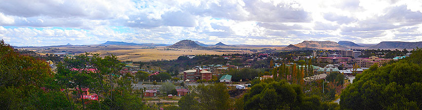 Maseru capital of Lesotho, in the background farmland in South Africa, on the right there is downtown Maseru. Image: Netroamer |
Searchable Map and Satellite View of Maseru using Google Earth DataSatellite view is showing Maseru, largest city and the national capital ofThe city has expanded eightfold since independence from the United Kingdom in 1966, and is now home to 20% of the population of Lesotho. About 220,000 people live in Maseru. When in Maseru you might visit some of the surrounding tourist spots: Thaba Bosiu, a sandstone plateau and the former stronghold of Basotho King Moshoeshoe I, King of Lesotho who established the nation of the Basotho, in Basutoland. Thaba Bosiu was the center of power and de facto capital. Moshoeshoe died in 1870, and was buried on Thaba Bosiu, the settlement has since been abandoned, and only ruins and the graves of various Basotho chiefs remain. The plateau is now a national monument. Maletsunyane Falls, a 192-meter-high waterfall near the town of Semonkong. Afriski, the skiing resort in Lesotho, located 3050 m above sea-level in the Maluti Mountains. Sehlabathebe National Park, located in the Maloti Mountains in Qacha's Nek District and is part of the transboundary UNESCO Maloti-Drakensberg World Heritage Site. The spectacular natural site contains many caves and rock-shelters with the largest and most concentrated group of paintings in Africa south of the Sahara. They represent the spiritual life of the San people (also known as Bushmen or Basarwa), who lived in this area over a period of 4,000 years. Just zoom in (+) to see Lesotho's Parliament building. The map shows a city map of Maseru with expressways, main roads and streets, zoom out to find the location of Moshoeshoe I International Airport (IATA code: MSU) 23 km (14.3 mi) by road (via Main South 1 Road) southeast of the city. To find a location use the form below. |
|
| To find a location type: street or place, city, optional: state, country. | Local Time Lesotho:
Saturday-June-27 16:30
Time zone SAST: UTC/GMT +2 hours
|
One World - Nations Online .:. let's care for this planet Promote that every nation assumes responsibility for our world. Nations Online Project is made to improve cross-cultural understanding and global awareness. More signal - less NOISE |
| Site Map
| Information Sources | Disclaimer | Copyright © 1998-2024:: nationsonline.org |

