Nations Online
All Countries in the World
Nations Online All Countries in the World | |
Home  |
___ Satellite View and Map of the City of Gaborone, Botswana |
About GaboroneSatellite view is showing Gaborone, largest city and the national capital of230,000 people live in the city of Gaborone (2011), that's more than10 % of the country's population. Spoken languages are English and Tswana (national). The city is Botswana's main hub, all major companies and institutions reside in Gaborone, as well as the Botswana Stock Exchange. The map shows a city map of Gaborone with expressways, main roads and streets, zoom out to find the location of Sir Seretse Khama International Airport (IATA code: GBE), 13.4 km (8.3 mi) by road (via Nelson Mandela Drive and Airport Road) north of the city. To find a location use the form below. To view just the map, click on the "Map" button. Just zoom in (+) to see Botswana's National Assembly at State House Drive. |
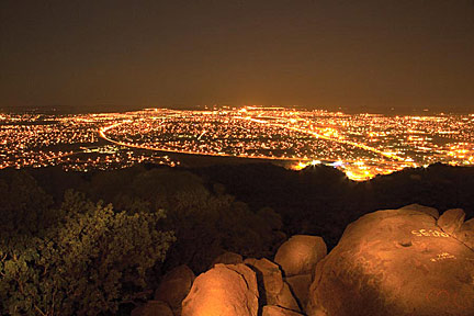 Botswana's capital city Gaborone at night. Image by: © botswana tourism Bookmark/share this page |
| To find a location type: street or place, city, optional: state, country. |
Local Time Botswana:
Sunday-April-14 17:30
Time Zone: Central Africa Time (CAT) GMT/UTC +2 |
One World - Nations Online .:. let's care for this planet Promote that every nation assumes responsibility for our world. Nations Online Project is made to improve cross-cultural understanding and global awareness. More signal - less NOISE |
| Site Map
| Information Sources | Disclaimer | Copyright © 1998-2023 :: nationsonline.org |

