Nations Online
All Countries in the World
Nations Online All Countries in the World | |
Home  |
___ Satellite View and Map of the City of Rustenburg, South Africa |
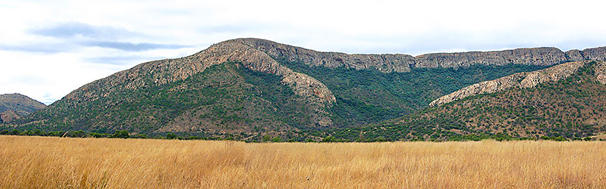 Magaliesberg near Rustenburg, the Magaliesberg has been declared a World Biosphere Reserve in June 2015. Image: Androstachys |
About Rustenburg Satellite View is showing Rustenburg, more a large town than a city in South Africa's countryside. Rustenburg is the seat of the Bojanala Platinum District in North West Province of South Africa. Satellite View is showing Rustenburg, more a large town than a city in South Africa's countryside. Rustenburg is the seat of the Bojanala Platinum District in North West Province of South Africa.The city is located in central norh of the country on the Highveld Plateau at the foot of the Magaliesberg (Cashan Mountains), a mountain range extending west and north from Pretoria . Rustenburg lies on a major highway (N4) about 140 km by road (via R24) from Johannesburg and 130 km from Pretoria (via N4). 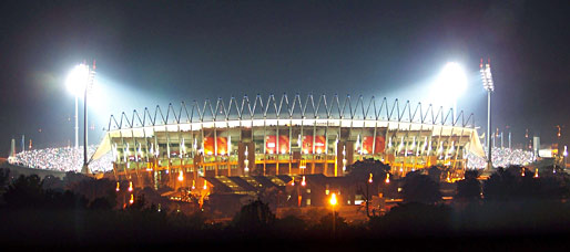 Royal Bafokeng Stadium at night. The stadium is located in Phokeng, the capital of the Royal Bafokeng Nation, 15 km (9 mi) north west of Rustenburg. Image: Courtesy of Royal Bafokeng Nation Spoken languages are Tswana (Setswana ) 55%, Tsonga 8%, Afrikaans 7%, Xhosa 6%, Sotho , and Sepedi. The city was the hometown of Paul Kruger, the State President (1883–1900) of the South African Republic (Transvaal). Rustenburg is one of the oldest towns in the North West province, it was founded in 1851 by Boers (the Dutch and Huguenot population that settled in southern Africa since the late 17th century). In the area around the city are the two largest platinum mines in the world. Sun City, a luxury resort and casino complex and a popular holiday and weekend destination is about 50 km (30 mi) away from Rustenburg. Nearby Pilanesberg National Park, a game reserve almost half the size of Belgium. Madikwe National Park situated further north on the border to Botswana is a game reserve of open grasslands and bushveld plains with the 2nd largest concentration of elephants in the country. The map shows a city map of Rustenburg with expressways, main roads and streets, and the location of Rustenburg Airfield and the Royal Bafokeng Stadium in Phokeng northwest of the city. Zoom out (-) to find. To find a location use the form below. |
||
| To find a location type: street or place, city, optional: state, country. |
Local Time Rustenburg:
Thursday-July-16 17:00
(UTC/GMT +2 hours) |
|
|
φ Latitude, λ Longitude (of Map center; move the map to see coordinates): , |
||||||
| Sorry! Google's pricing policy has made it impossible for us to continue showing Google Maps. We apologize for any inconvenience. Google Map: Searchable Map and Satellite View of the City of Rustenburg, North West Province, South Africa. City Coordinates: 25°40′05″S 27°14′19″E |
Bookmark/share this page |
|||||
| More about South Africa: Other major Cities in South Africa: Country: South Africa key statistical data. Continent: |
Weather Conditions Rustenburg
External Links: Rustenburg Herald Local News. Wikipedia: Rustenburg Wikipedia article about Rustenburg. |
Explore more:
Related Consumer Information:
|
||||
Other Countries of Southern Africa: Botswana | Lesotho | Namibia | Swaziland Maps of other Countries of Southern Africa: Botswana Map | Namibia Map | Swaziland Map Searchable Maps of other Countries of Southern Africa: Botswana Interactive Map | Namibia Interactive Map | Lesotho Interactive Map | Swaziland Interactive Map Other Major Cities in Southern Africa: Gaborone | Lobamba | Maseru | Mbabane | Windhoek |
||||||
Map Help [ show ] |
||||||
One World - Nations Online .:. let's care for this planet Promote that every nation assumes responsibility for our world. Nations Online Project is made to improve cross-cultural understanding and global awareness. More signal - less NOISE |
| Site Map
| Information Sources | Disclaimer | Copyright © 1998-2024:: nationsonline.org |

