Nations Online
All Countries in the World
Nations Online All Countries in the World | |
Home  |
___ Satellite View and Map of South Africa |
 The Blyde River Canyon is located in Mpumalanga, it is the northern part of the Drakensberg escarpment. The Blyde River Canyon is located in Mpumalanga, it is the northern part of the Drakensberg escarpment.Image: Martin Heigan |
About South Africa Satellite view is showing South Africa, the country at the southern tip of the African continent
with the South Atlantic Ocean in west and the Indian Ocean in east. South Africa is bordered by Botswana, Mozambique, Namibia, Swaziland, and Zimbabwe. The Kingdom of Lesotho is entirely surrounded by South Africa. Satellite view is showing South Africa, the country at the southern tip of the African continent
with the South Atlantic Ocean in west and the Indian Ocean in east. South Africa is bordered by Botswana, Mozambique, Namibia, Swaziland, and Zimbabwe. The Kingdom of Lesotho is entirely surrounded by South Africa.Africa's southernmost country occupies an area of 1,2 million km², compared it is larger than four times the size of Italy, or somewhat less than twice the size of the U.S. state of Texas. 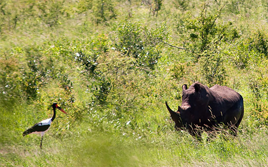 A Saddlebilled Stork and a Rhino in Kruger National Park, one of the largest game reserves in Africa. South Africa's first national park is situated in the Limpopo and Mpumalanga provinces. Image: Chris Eason Geographical highlight is the Drakensberg ("Dragons Mountain"), the highest mountain range in Southern Africa, with the highest point in the country is Mafadi a peak with 3,450 m (11,320 ft) on the border of South Africa and Lesotho. There are two significant rivers in South Africa, the Limpopo defines a part of South Africa's borders with Botswana and the Orange, a river with an enormous watershed; the longest river in South Africa defines some portions of the country's border with Namibia. South Africa has a population of 54 million people (Official estimate 2014); spoken languages are English, Afrikaans, Zulu, Xhosa, and others. the country's administrative capital is Pretoria; legislative capital is Cape Town and the judicial capital is Bloemfontein (Mangaung), largest city is Johannesburg. Some points of interest in South Africa: Cape Town, with Victoria & Alfred Waterfront, Cape of Good Hope, Robben Island (site where Nelson Mandela spent 18 of his 27 years in prison), Signal Hill and Table Mountain. Garden Route, along the coast from Mossel Bay in the Western Cape to the Storms River in the Eastern Cape, scenic stopovers are George, Knysna, Nature's Valley, Plettenberg Bay, Tsitsikamma National Park (protected area), Victoria Bay. Cape Winelands, South Africa wines, the cultural landscape in the Western Cape Province is also on the UNESCO World Heritage Tentative List. Cradle of Humankind, (Gauteng province) the Fossil Hominid Sites of South Africa about 50 kilometres northwest of Johannesburg. Nature and Game Reserves: subtropical green Blyde River Canyon (Mpumalanga), Hluhluwe-Umfolozi Game Reserve (oldest proclaimed nature reserve in Africa, KwaZulu Natal); Kruger National Park, one of Africa’s largest game reserves with a high density of wild animals including the Big 5; The Map shows South Africa with cities, expressways, main roads and streets. To find a location use the form below. |
|
| To find a location type: street or place, city, optional: state, country. |
Local Time South Africa:
Thursday-April-25 08:29
(UTC/GMT +2 hours)
|
|
φ Latitude, λ Longitude (of Map center; move the map to see coordinates): , |
||||||||||
| Sorry! Google's pricing policy has made it impossible for us to continue showing Google Maps. We apologize for any inconvenience. Google Map: Searchable map and satellite view of South Africa. |
Bookmark/share this page |
|||||||||
| More about South Africa: Major Cities in South Africa: Country: Detailed Map of South Africa. Map shows South Africa's Provinces. South Africa key statistical data. Continent: |
Weather Conditions Johannesburg
Weather Conditions Cape Town
|
Related Consumer Information:
|
||||||||
Maps of other Countries of Southern Africa: Botswana Map | Mozambique Map | Namibia Map | Swaziland Map | Zimbabwe Map Searchable Maps of other Countries of Southern Africa: Botswana Interactive Map | Mozambique Interactive Map | Namibia Interactive Map Lesotho Interactive Map | Swaziland Interactive Map | Zimbabwe Interactive Map Other Major Cities in Southern Africa: Gaborone | Harare | Lobamba | Maseru | Mbabane | Windhoek |
||||||||||
Map Help [ show ] |
||||||||||
One World - Nations Online .:. let's care for this planet Promote that every nation assumes responsibility for our world. Nations Online Project is made to improve cross-cultural understanding and global awareness. More signal - less NOISE |
| Site Map
| Information Sources | Disclaimer | Copyright © 1998-2023 :: nationsonline.org |


