Nations Online
All Countries in the World
Nations Online All Countries in the World | |
Home  |
___ Satellite View and Map of Botswana |
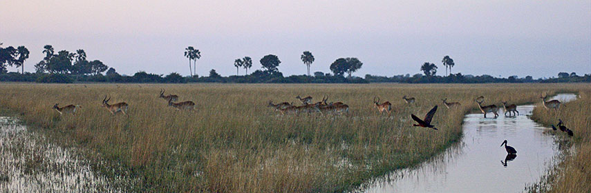 A group of Lechwe (Antelopes) and some birds in the Okavango Delta, Botswana. Image: PanBK |
About Botswana Satellite view is showing Botswana, a landlocked nation in Southern Africa, north of South Africa. The country is also bordered by Namibia in west, it has a short border with Zambia (0.15 km) in north, and it borders Zimbabwe in east. Satellite view is showing Botswana, a landlocked nation in Southern Africa, north of South Africa. The country is also bordered by Namibia in west, it has a short border with Zambia (0.15 km) in north, and it borders Zimbabwe in east.With an area of 582,000 sq km the country is slightly bigger than France, or slightly smaller than the U.S. state of Texas. Botswana's landscape is flat with only some hills in south east. 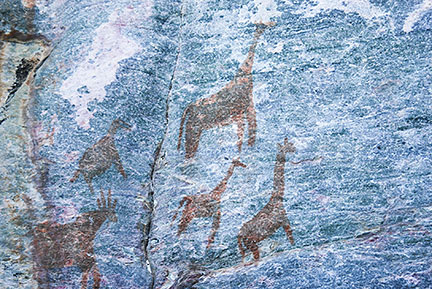 Rock art giraffes at Tsodilo Hills. Over 4,500 paintings are preserved in an area of only 10 km² of the Kalahari Desert. Image: Oliver Vass The Tsodilo is a site of a unique religious and spiritual significance to local San peoples. The site became a UNESCO World Heritage Site Botswana is sparsely populated, since large parts of the country are covered by the Kalahari Desert in west and south west, where living conditions for humans are rather hostile. The world's 46th-largest country has a population of under 2 million people. Capital city is Gaborone. Spoken languages are English (official) and Setswana (Tswana). The map shows Botswana with national parks, game reserves, cities, towns, expressways, main roads and streets. To find a location use the form below. |
|
| To find a location type: street or place, city, optional: state, country. |
Local Time Botswana:
Friday-April-26 23:34
Time Zone: Central Africa Time (CAT) GMT/UTC +2 |
|
φ Latitude, λ Longitude (of Map center; move the map to see coordinates): , |
||||||
| Google Maps:Searchable Map of Botswana. |
Bookmark/share this page |
|||||
| More about Botswana: Cities: Country: Continent: |
Weather Conditions Botswana at Gaborone Seretse Khama International Airport
|
Related Consumer Information:
|
||||
| Other Countries of Southern Africa: Lesotho | Namibia | South Africa | Swaziland Maps of other Countries of Southern Africa: Namibia Map | South Africa Map | Swaziland Map Searchable Maps of other Countries of Southern Africa: Namibia Interactive Map | Lesotho Interactive Map | South Africa Interactive Map | Swaziland Interactive Map Major Cities in Southern Africa: Bloemfontein | Cape Town | Durban | Johannesburg | Lobamba | Maseru | Mbabane | Nelspruit | Polokwane Port Elizabeth | Pretoria | Rustenburg | Windhoek |
||||||
Map Help [ show ] |
||||||
One World - Nations Online .:. let's care for this planet Promote that every nation assumes responsibility for our world. Nations Online Project is made to improve cross-cultural understanding and global awareness. More signal - less NOISE |
| Site Map
| Information Sources | Disclaimer | Copyright © 1998-2023 :: nationsonline.org |

