
|
|
___ Political Map of Namibia |
|
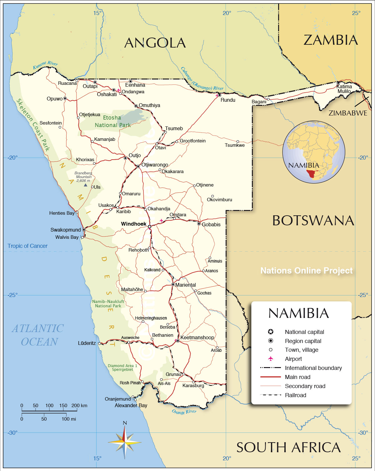
| About Namibia Map is showing Namibia, a nation in southwestern Africa, with a coastline on the Atlantic Ocean. The country is bordered by Botswana, Zambia, and Zimbabwe. The Orange River to the south marks the southern border of Namibia to South Africa. The Kunene River and the Okavango River form partly the nations northern border with Angola. Only on 21 March 1990, Namibia gained independence from South Africa. The country's name is derived from the Namib Desert. With an area of 824,292 km² (318,260 sq. mi.), Namibia is almost twice the size of Sweden, or slightly more than half the size of the U.S. state of Alaska, it is the least densely populated country in the world (after Mongolia) Namibia's natural landscapes consists of five major geographical areas: the Central Plateau, the Great Escarpment, the Namib Desert, the Kalahari Desert and the Kavango-Caprivi Region. The Central Plateau occupies the central part of the country from north to south, bordered in west by the Great Escarpment and the Namib Desert with its arid coastal plains. The Namib is probably the oldest desert in the world. Along the Central Plateau to the east lies the Kalahari Desert, the vast semi-arid sandy savannah which extends into South Africa and Botswana. The Great Escarpment is a mountainous region with elevations up to 2,000 meters, lies predominantly within Lesotho and South Africa, but extends into Angola, Namibia, Swaziland, Mozambique, and Zimbabwe. Located in the northwestern Namib Desert near the coast, is the Brandberg Massif with the Königstein summit (German for 'King's Stone'), the country's highest elevation. The Brandberg mountain, together with the Erongo Mountains and the Spitzkoppe are geologically not part of the Great Escarpment, they belong to the Damara Formation and are of volcanic origin. The Kavango-Caprivi Region, also sometimes called the Bushveld is a sub-tropical woodland area in north eastern Namibia along the Angolan border. The map shows Namibia with surrounding countries, international borders, the national capital Windhoek, province capitals, cities, villages, roads, railroads and major airports. |
 Bookmark/share this page |
 One World - Nations Online All Countries of the World |
|
|
||
 Political Map of Namibia |
|||||||
Cities and Towns in NamibiaMap shows the location of following cities and villages in Namibia:Capital and largest city is Windhoek (pop.: 326,000), Rundu, the capital of the Kavango-East Region is Namibias second largest city with a growing population of now 64,000 inhabitants, Walvis Bay (Ezorongondo), a deepwater harbour and third largest city in the country with about 62,000 people. Swakopmund (Otjozondjii), capital of the Erongo district (pop.: 45,000). Population figures according to Namibia 2011 Population and Housing Census. Other Namibian cities and towns: (some towns with traditional or pre-colonial names in parenthesis) Ais-Ais, Aranos, Aroab, Aus, Bagani, Berseba, Bethanien, Eenhana, Gobabis (Epako), Gochas, Grootfontein (Otjivanda), Grunau, Helmeringhausen, Henties Bay, Kalkrand, Kamanjab (Okamanja), Karasburg, Karibib (Otjandjomboimwe), Katima Mulilo, Keetmanshoop, Khorixas, Lüderitz, Maltahöhe, Mariental, Okahandja, Okakarara, Okovimburu, Omaruru, Omitara, Omuthiya, Ondangwa, Opuwo, Oranjemund, Oshakati, Otavi, Otjetjekua, Otjinene, Otjiwarongo, Outapi, Outjo, Rehoboth, Rosh Pinah, Ruacana, Sesfontein, Tsumeb (Okavisume), Tsumkwe, Uls, and Usakos (Okanduu). |
More about Namibia: Cities: Country: Continent: |
Windhoek Weather Conditions
|
Explore More:
Related Consumer Information:
|
||||
| Other Countries of Southern Africa: Botswana | Lesotho | South Africa | Swaziland Maps of other Countries of Southern Africa: Botswana Map | South Africa Map | Swaziland Map Searchable Maps of other Countries of Southern Africa: Botswana Interactive Map | Lesotho Interactive Map | South Africa Interactive Map | Swaziland Interactive Map Other Major Cities in Southern Africa: Bloemfontein | Cape Town | Durban | Gaborone | Johannesburg | Lobamba | Maseru | Mbabane | Nelspruit | Polokwane Port Elizabeth | Pretoria | Rustenburg |
|||||||
One World - Nations Online .:. let's care for this planet Every nation is responsible for the current state of our world. |
| Site Map
| Information Sources | Disclaimer: Privacy Policy, etc. Contact: [email protected] | Copyright © 1998-2021 :: nationsonline.org |
