Nations Online
All Countries in the World
Nations Online All Countries in the World | |
Home  |
___ Satellite View and Map of Lobamba, Swaziland |
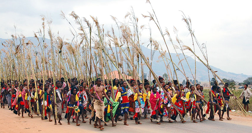 Reed Dance Festival at Ludzidzini Royal Village, Lobamba, Swaziland. |
About Lobamba Satellite view is showing Lobamba, the old royal capital and now the legislative capital of Satellite view is showing Lobamba, the old royal capital and now the legislative capital of According to traditional Swazi customs, Lobamba is the residence of the Ndlovukazi (the She Elephant; the Queen Mother) and is thereby the spiritual home of the Swazi nation. The city is the seat of the parliament. It has a population of about 6,000 people. Official languages are English and siSwati (Swazi). The map shows a city map of Lobamba with expressways and main roads, zoom out to find the location of Matsapha Airport (IATA code: MTS) located in south east at the town of Matsapha, and the location of Sikhuphe International Airport now King Mswati III International Airport (IATA code: SHO) Swaziland’s future primary airport about 73 km (45 mi) by road (via MR103, MR18, MR3) east of Lobamba. To find a location use the form below. |
||
| To find a location type: street or place, city, optional: state, country. | Local Time Swaziland:
Friday-April-26 06:25
(UTC/GMT +2 hours)
|
|
|
φ Latitude, λ Longitude (of Map center; move the map to see coordinates): , |
||||||
| Google Earth: Searchable Map and Satellite view of Lobamba, royal and legislative capital of the Kingdom of Swaziland. City Coordinates: 26°28′S 31°12′E |
Bookmark/share this page |
|||||
| More about Swaziland: Cities: Country: Continent: External Links: Times of Swaziland Local news. Wikipedia: Lobamba | Weather Conditions Manzini
|
Related Consumer Information:
| ||||
| Other Countries of Southern Africa: Botswana | Lesotho | Namibia | South Africa Maps of other Countries of Southern Africa: Botswana Map | Namibia Map | South Africa Map Searchable Maps of other Countries of Southern Africa: Botswana Interactive Map | Namibia Interactive Map | Lesotho Interactive Map | South Africa Interactive Map Major Cities in Southern Africa: Bloemfontein | Cape Town | Durban | Gaborone | Johannesburg | Maseru | Nelspruit | Polokwane Port Elizabeth | Pretoria | Rustenburg | Windhoek |
||||||
Map Help [ show ] |
||||||
One World - Nations Online .:. let's care for this planet Promote that every nation assumes responsibility for our world. Nations Online Project is made to improve cross-cultural understanding and global awareness. More signal - less NOISE |
| Site Map
| Information Sources | Disclaimer | Copyright © 1998-2023 :: nationsonline.org |

