Nations Online
All Countries in the World
Nations Online All Countries in the World | |
Home  |
___ Satellite View and Map of the City of Johannesburg, Gauteng province, South Africa |
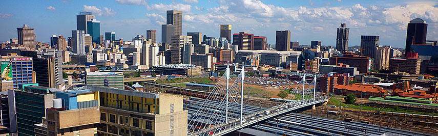 Johannesburg Central Business District, with Nelson Mandela Bridge which crosses over 42 railway lines and links the two main business areas of Joburg: Braamfontein and Newtown. Image: Evan Bench |
About Johannesburg Satellite View is showing Johannesburg, the capital of the province of Gauteng, largest city and the industrial and mining capital of Satellite View is showing Johannesburg, the capital of the province of Gauteng, largest city and the industrial and mining capital of The city, also known as Jo'burg or Jozi, is located on the Highveld, a plateau region in South Africa, at an elevation of 1,750 m (5,740 ft). Johannesburg is the seat of the provincial government and the site of several government branch offices, consular offices and other governmental institutions, it is home to the Constitutional Court – South Africa's highest court. The city became famous for so many acts of defiance against the apartheid government. Jo'burg is the center of a large-scale gold and diamond trade. The gateway to South Africa's northern provinces and to Southern Africa is famous for Gold Reef City, a large amusement park, and for Johannesburg Lion Park, housing a wide variety of lions and other wild animals. According to GaWC Research Johannesburg is an Alpha - city, in their ranking of Global Cities, the only World City on the African Continent. Johannesburg has a population of almost 4 million inhabitants and 7 million people live in the Greater Johannesburg Metropolitan Area. The 2010 FIFA World Cup finals have been held in Johannesburg's Soccer City, located in the Soweto area. Joburg became the focus of international attention again in Dec 2013, when Nelson Mandela died in his home in Houghton Estate on the 5th December 2013. Just zoom in (+) to see the Carlton Center in downtown Johannesburg, the 50 floor skyscraper at 223 m (730 ft) is a shopping center and the tallest building in Africa. The Map shows a city map of Johannesburg with expressways, main roads and streets, zoom out (-) to find Johannesburg OR Tambo International Airport (IATA code: JNB) northeast of the city center. To find a location use the form below. |
|
| To find a location type: street or place, city, optional: state, country. |
Local Time Johannesburg:
Friday-April-26 15:43
Time zone: South Africa Standard Time (SAST) :: UTC/GMT +2 hours |
|
φ Latitude, λ Longitude (of Map center; move the map to see coordinates): , |
||||||
| Sorry! Google's pricing policy has made it impossible for us to continue showing Google Maps. We apologize for any inconvenience. Google Map: Searchable Map and Satellite View of the City of Johannesburg, South Africa. City Coordinates: 26°12′16″S 28°2′44″E |
Bookmark/share this page |
|||||
| More about South Africa: Maps of other major Cities in South Africa: Country: South Africa key statistical data. Continent: |
Weather Conditions Johannesburg
External Links: City of Johannesburg Johannesburg's official web site. Johannesburg International Airport OR Tambo International Airport (JNB) The Citizen South Africa News. Mail & Guardian South Africa News. Wikipedia: Johannesburg Wikipedia article about Johannesburg. |
Explore more:
Related Consumer Information:
|
||||
Other Countries of Southern Africa: Botswana | Lesotho | Namibia | Swaziland Maps of other Countries of Southern Africa: Botswana Map | Namibia Map | Swaziland Map Searchable Maps of other Countries of Southern Africa: Botswana Interactive Map | Namibia Interactive Map | Lesotho Interactive Map | Swaziland Interactive Map Other Major Cities in Southern Africa: Gaborone | Lobamba | Maseru | Mbabane | Windhoek |
||||||
Map Help [ show ] |
||||||
One World - Nations Online .:. let's care for this planet Promote that every nation assumes responsibility for our world. Nations Online Project is made to improve cross-cultural understanding and global awareness. More signal - less NOISE |
| Site Map
| Information Sources | Disclaimer | Copyright © 1998-2023 :: nationsonline.org |