
| Home |
|
|
|
___ Political Map of Botswana |
|
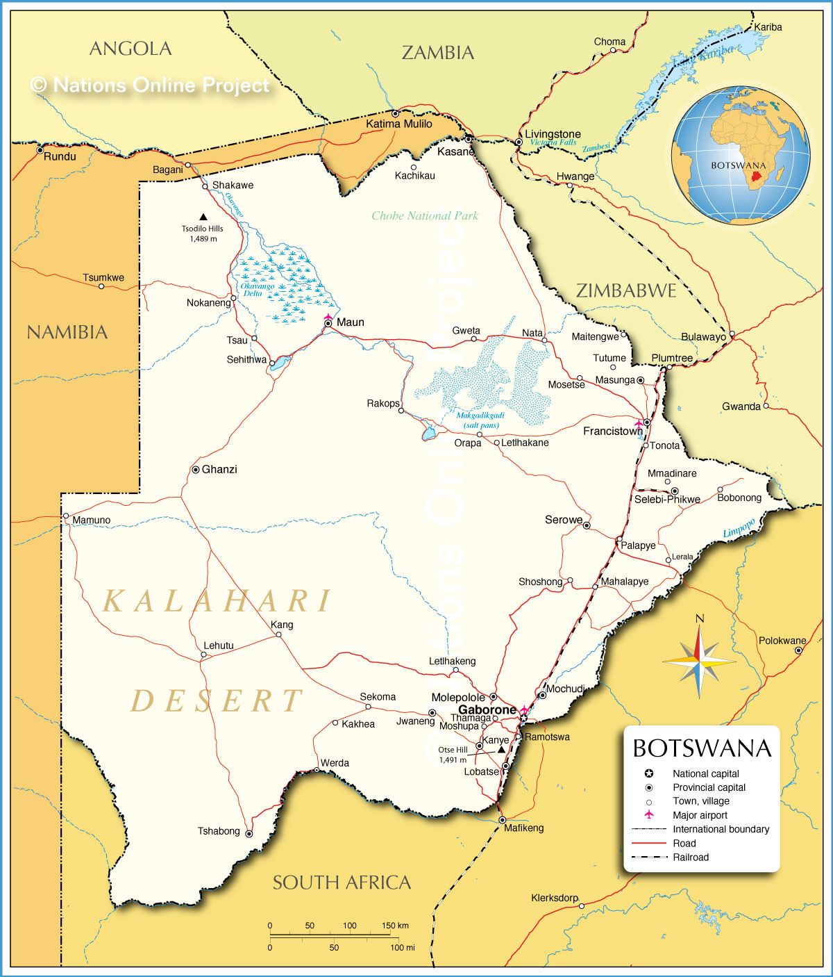
| About Botswana Botswana is a landlocked country in Southern Africa located north of South Africa. The country is sparsely populated because up to 70% of the country is covered by the Kalahari Desert. Botswana's population of only 2 million people is concentrated in the eastern part of the country. Highest elevation are the Otse Hill (1,491 m) in central south of the country. With an area of 582,000 sq km the country is slightly bigger than France, or slightly smaller than the U.S. state of Texas. Major geographical features of Botswana. The Kalahari "a waterless place", a vast arid to semi-arid area in Southern Africa covering much of Botswana and parts of Namibia and South Africa. The Okawango Delta, the Okawango river does not make it to the sea, instead the river spreads into a delta in the Kalahari Desert where most of its water is lost to evaporation and transpiration, it is the world's largest inland delta. Each year approximately 11 cubic kilometers of water irrigate the 15,000 km² area and some flood-waters drain into Lake Ngami, east of Sehithwa village. The Moremi Game Reserve, a National Park, spreads across the eastern side of the delta. The Makgadikgadi Pans, one of the largest salt flats in the world. The pan is all that remains of the ancient Lake Makgadikgadi, which once covered an area larger than Switzerland, but evaporated several thousand years ago. Map is showing Botswana, and the surrounding countries with international borders, the national capital Gaborone, province capitals, major cities, main roads, railroads and airports. Principal airport of Botswana is Sir Seretse Khama International Airport (IATA code: GBE), about 15 kilometres (9 mi) north of Gaborone, other major airports in Botswana are located at Francistown, Kasane, and Maun. Border Countries: Namibia, South Africa, and Zimbabwe |
 Bookmark/share this page |
 One World - Nations Online All Countries of the World |
|
|
||
 Political Map of Botswana |
|||||||
| Cities and Towns in Botswana Map shows the location of following cities and villages in Botswana: Bobonong, Francistown (second largest city), Gaborone, Ghanzi, Gweta, Jwaneng, Kachikau, Kakhea, Kang, Kanye, Kasane, Lehutu, Lerala, Letlhakane, Letlhakeng, Lobatse, Mahalapye, Maitengwe, Mamuno, Masunga, Maun, Mmadinare, Mochudi, Molepolole, Mosetse, Moshupa, Nata, Nokaneng, Orapa, Palapye, Rakops, Ramotswa, Sehithwa, Sekoma, Selebi-Phikwe, Serowe, Shakawe, Shoshong, Thamaga, Tonota, Tsau, Tshabong, Tutume, and Werda. |
More about Botswana: Cities: Country: Continent: |
Gaborone Current Weather Conditions at Seretse Khama International Airport
|
Related Consumer Information: | ||||
| Other Countries of Southern Africa: Lesotho | Namibia | South Africa | Swaziland Maps of other Countries of Southern Africa: Namibia Map | South Africa Map | Swaziland Map Searchable Maps of other Countries of Southern Africa: Namibia Interactive Map | Lesotho Interactive Map | South Africa Interactive Map | Swaziland Interactive Map Major Cities in Southern Africa: Bloemfontein | Cape Town | Durban | Johannesburg | Lobamba | Maseru | Mbabane | Nelspruit | Polokwane Port Elizabeth | Pretoria | Rustenburg | Windhoek |
|||||||
One World - Nations Online .:. let's care for this planet Every nation is responsible for the current state of our world. |
| Site Map
| Information Sources | Disclaimer: Privacy Policy, etc. Contact: [email protected] | Copyright © 1998-2021 :: nationsonline.org |
