Nations Online
All Countries in the World
Nations Online All Countries in the World | |
Home  |
___ Satellite View and Map of Cape Town (Africaans: Kaapstad), Western Cape, South Africa
|
 Panorama view of Cape Town's City Bowl as seen from Lion's Head.The City Bowl is a natural amphitheatre-shaped area bordered by Table Bay and defined by the mountains of Signal Hill, Lion's Head, Table Mountain and Devil's Peak. The bowl is quite good to see when you use the terrain display on the map below. Image by: AerialcamSA |
About Cape Town Satellite view is showing Cape Town, second most populous city and the legislative capital of Satellite view is showing Cape Town, second most populous city and the legislative capital of Cape Town was founded in 1652 by the Dutch East India Company (VOC) as a resupply station for ships travelling from Amsterdam to the spice-producing islands of East Africa (Zanzibar) and Batavia (Jakarta, Dutch East Indies, now Indonesia). For their future shipping route service area, the Dutch first built a mud fort (Fort de Goede Hoop), then they laid out irrigated vegetable gardens and orchards and traded with the local Khoikhois for meat. Relics of the Dutch market gardening can still be visited at Company's Garden. To keep the town running, the settlers needed more personnel, and so they undertook a slaving voyage from the Cape to Mauritius and Madagascar. Between 1666 and 1679 the Dutch built another bastion to better fortify and organize their assets. With this work done, the Dutch consolidated their position of the first permanent European settlement in Southern Africa and 'kaap stad' became the economic center of the Cape Colony. 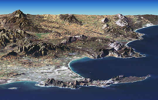 Satellite image of Cape peninsula with Cape Town, Table Mountain, False Bay (right) and Table Bay (left) with the small Robben Island. Image: NASA Cape Town is one of the most popular international tourist destination not only in South Africa, but in Africa. The 'African capital of cool' is #2 in National Geographic's Top 10 list of Beach Cities. Some of the highlights are: Table Mountain Aerial Cableway (get the whole picture on top of Table Mountain), Grand Parade (town square - surrounded by the Cape Town City Hall, the Castle of Good Hope, and the Cape Town railway station), Robben Island (former prison island, most prominent inmate: Nelson Mandela), Cape Peninsula with Cape of Good Hope (the southern end of Africa, known for stormy weather and rough seas), Groot Constantia and Constantia Valley (sprawling mansions and lush vineyards), South African National Gallery (Dutch, French and British works from the 17th to the 19th century), Iziko South African Museum And Planetarium at the Company's Garden (fossils, animals, human tools & clothing). Just zoom in to see Cape Town City Center in a 45-degree view. The map shows a city map of Cape Town with expressways, main roads and streets, and the location of Cape Town International Airport (IATA code: CPT) 17.7 km (11 mi) by road (via N2) east of the city. To the west you see Cape Town's landmark the Table Mountain with its flat top. To find a location use the form below. Map Help |
|
| To find a location type: street or place, city, optional: state, country. | Local Time Cape Town:
Sunday-April-28 06:10
UTC/GMT +2 hours |
|
φ Latitude, λ Longitude (of Map center; move the map to see coordinates): , |
||||||
| Google Earth: Satellite View and Map of Cape Town, Western Cape, South Africa. City Coordinates: 33°55′31″S 18°25′26″E |
Bookmark/share this page |
|||||
| More about South Africa: Other major Cities in South Africa: Country: South Africa key statistical data. Continent: External Links Cape Town (official web site) Cape Times Local news. Wikipedia: Cape Town |
Weather Conditions Cape Town
|
Explore more:
Related Consumer Information:
|
||||
Other Countries of Southern Africa: Botswana | Lesotho | Namibia | Swaziland Maps of other Countries of Southern Africa: Botswana Map | Namibia Map | Swaziland Map Searchable Maps of other Countries of Southern Africa: Botswana Interactive Map | Namibia Interactive Map | Lesotho Interactive Map | Swaziland Interactive Map Other Major Cities in Southern Africa: Gaborone | Lobamba | Maseru | Mbabane | Windhoek |
||||||
Map Help [ show ] |
||||||
One World - Nations Online .:. let's care for this planet Promote that every nation assumes responsibility for our world. Nations Online Project is made to improve cross-cultural understanding and global awareness. More signal - less NOISE |
| Site Map
| Information Sources | Disclaimer | Copyright © 1998-2023 :: nationsonline.org |

