Nations Online
All Countries in the World
Nations Online All Countries in the World | |
Home  |
___ Satellite View and Map of French Guiana (Guyane) |
About French GuianaMap is showing the South American overseas region of France, occupying the smallest portion of the continent, bordering the North Atlantic Ocean in north, countries with international borders to French Guiana are Brazil and Suriname.With an area of 83,534 km² the country is about the size of Austria, or slightly larger than the U.S. state of South Carolina. Guyane's landscape varies from a coastal strip with marshes and swamps, where the majority of the people live, to a dense, near-inaccessible rainforest which gradually rises to the modest peaks of the remote Tumuk Humak mountains along the Brazilian border area. French Guiana's highest elevation is at Bellevue de l'Inini in Maripasoula province with 851 m (2,792 ft.). French Guiana's climate is tropical, hot, and humid, with little seasonal temperature variation. Guyane has a population of just 250,000 people (in 2014). The official language is French, but a number of other local languages are spoken including English, French Guiana creole, six Amerindian languages, and four Maroon dialects. Capital city is Cayenne. The ESA Space Center, the European spaceport, is located near the city of Kourou. There are two reasons for its location, first: it's near the equator, with today's technology, rockets need the centrifugal force of spinning earth that provides a good deal of extra velocity for free when launched eastward, and second: uninhabited territory to the east (like an ocean), so that the initial stages of the rockets or debris from a launch failure don't wreak havoc on human habitations. The map shows French Guiana with cities, towns, expressways, main roads and streets. To find a location use the form below. |
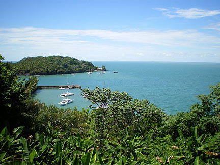 View from the île Royale: harbor and St Joseph island. Île Royale (Royal Island) is the largest of the three Îles du Salut, in the Atlantic Ocean off the coast of French Guiana. Image: Tylda Bookmark/share this page 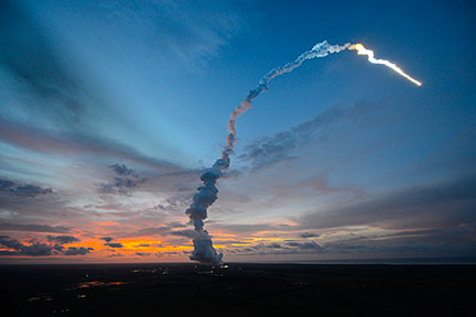 ATV-4 Albert Einstein lifts off from Kourou. Image: DLR German Aerospace Center; ESA/S |
| To find a location type: street or place, city, optional: state, country. |
Local Time French Guiana:
Thursday-April-18 13:33
Standard time zone: French Guiana Time (GFT) UTC/GMT -3 hours |
|
φ Latitude, λ Longitude (of Map center; move the map to see coordinates): , |
||||||
| Google Maps: Searchable Map of French Guiana (Guyane) |
||||||
| More about French Guiana: Landmarks: Cities: Country: Continent: Historically related Countries: |
Current Weather Conditions Cayenne
|
Related Consumer Information:
|
||||
| Searchable Maps of other Countries in South America: Argentina, Brazil, Bolivia, Chile, Colombia, Ecuador, French Guiana Guyana, Paraguay, Peru, Suriname, Uruguay, Venezuela Maps of other Countries in South America: Argentina Map, Brazil Map, Bolivia Map, Chile Map, Colombia Map, Ecuador Map, French Guiana Map, Guyana Map, Paraguay Map, Peru Map, Suriname Map, Uruguay Map, Venezuela Map Countries and Territories of The Americas |
||||||
Map Help [ show ] |
||||||
One World - Nations Online .:. let's care for this planet Promote that every nation assumes responsibility for our world. Nations Online Project is made to improve cross-cultural understanding and global awareness. More signal - less NOISE |
| Site Map
| Information Sources | Disclaimer | Copyright © 1998-2023 :: nationsonline.org |

