 |
|
___ Political Map of Nigeria |
|
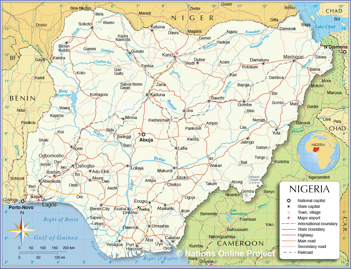
Nigeria is a country on the coast of West Africa, bordered by the Bight of Benin and the Gulf of Guinea in south. Nigeria is bordered by Benin, Cameroon, Chad, and Niger, it shares maritime borders with Equatorial Guinea, Ghana, and São Tomé and Príncipe. With an area of 923,768 km² the country is almost four times the size of the UK or slightly more than twice the size of the U.S. state California. Nigeria's main rivers are the Niger and the Benue, the main tributary of the Niger. The country's highest point is Chappal Waddi (or Gangirwal) with 2,419 m (7,936 ft), located in the Adamawa mountains in the Gashaka-Gumti National Park, Taraba State, on the border with Cameroon. The Federal Republic of Nigeria (its official name) has a population of of 177.5 million people (UN est. 2014) making it Africa's most populous country. Capital city is Abuja located in the center of the nation, while Lagos is the primary port and largest city. Spoken languages are English (official), Hausa, Ibo, Yoruba, and others. The detailed map below is showing Nigeria and surrounding countries with international borders, state boundaries, the national capital Abuja, state capitals, major cities, main roads, railroads and airports. |
 Bookmark/share this page 
|
 One World - Nations Online All Countries of the World |
|
|
||
 Political Map of Nigeria Map based on a UN map. Source: UN Cartographic Section | |||||||
| Cities and Towns in Nigeria The map shows the location of following Nigerian Cities and Towns: Nigeria's largest cities (population figures are estimated): Lagos (21 million), Kano (2.5 - 3 million), Ibadan (3.2 million), Abuja (capital; 1 million), Port Harcourt (1.4 million), Benin City (1.2 million), Kaduna (800,000) Other Cities and Towns in Nigeria: Aba, Abakaliki, Abeokuta, Abong, Abuja, Ado-Ekiti, Akure, Amper, Ankpa, Asaba, Auchi, Awka, Azare, Badeggi, Baga, Bajoga, Bali, Bama, Baro, Bauchi, Bida, Biliri, Birnin Kebbi, Biu, Calabar, Damasak, Damaturu, Damboa, Dan Gulbi, Daura, Dikwa, Dutse, Enugu, Funtua, Ganye, Gboko, Gembu, Gombe, Gombi, Gumel, Gummi, Gusau, Hadejia, Ife, Ikeja, Ikom, Ilaro, Illela, Ilorin, Iseyin, Iwo, Jalingo, Jos, Kajama, Kamba, Kanfanchan, Kari, Katsina, Kaura Namoda, KisiIbi, Koko, Kontagora, Kwolla, Lafia, Lagos, Lau, Lokaja, Maiduguri, Makurdi, Minna, Mubi, Nguru, Numan, Ogbomosho, Ogoja, Ondo, Onitsha, Ore, Oron Sapele, Oshogbo, Oturkpo, Owerri, Owo, Oyo, Pankshin, Potiskum, Sabon Benin Gwari, Shaki, Sokoto, Takum, Tungo, Umuahia, Uyo, Warri, Wawa, Wudil, Wukari, Wurno, Yenagoa, Yola/Jimeta, Zaria |
More about Nigeria Cities: Country: Continent: |
Current Weather Conditions Lagos: |
Explore More:
Related Consumer Information:
|
||||
Political Maps of other Countries in West Africa: Benin Map | Burkina Faso Map | Cape Verde Map | Côte d'Ivoire Map | Ghana Map | Guinea Map | Guinea-Bissau Map Liberia Map | Mali Map | Mauritania Map | Niger Map | Senegal Map | Sierra Leone Map | Togo Map |
|||||||
One World - Nations Online .:. let's care for this planet Every nation is responsible for the current state of our world. |
| Site Map
| Information Sources | Disclaimer: Privacy Policy, etc. Contact: [email protected] | Copyright © 1998-2021 :: nationsonline.org |