
| Home |
|
|
|
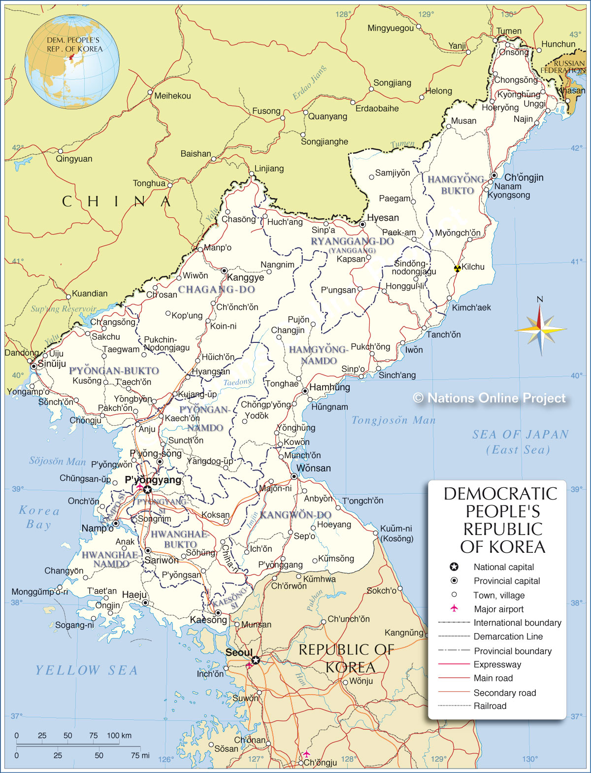
___ Administrative Map of North Korea | |
About North Korea |
|
| Map is showing North Korea and the surrounding countries with international borders, provinces, provincial boundaries, the national capital P'yongyang, provincial capitals, major cities, main roads, railroads and major airports. Border Countries: China, Russia, South Korea Administrative Divisions of North KoreaProvinces:Chagang Province (Chagang-do); Capital: Kanggye Hamgyŏng North Province (Hamgyŏng-pukto); Capital: Chongjin Hamgyŏng South Province (Hamgyŏng-namdo); Capital: Hamhŭng Hwanghae North Province (Hwanghae-pukto); Capital: Sariwŏn Hwanghae South Province (Hwanghae-namdo); Capital: Haeju Kangwŏn Province (Kangwŏn-Do); Capital: Wŏnsan P'yŏngan North Province (P'yŏngan-pukto); Capital: Sinŭiju P'yŏngan South Province (P'yŏngan-namdo); Capital: P'yŏngsŏng Ryanggang Province (Ryanggang-do) also spelled Yanggang; Capital:Hyesan |
 Bookmark/share this page |
 One World - Nations Online all countries of the world |
|
|
||
 Map of North Korea Map based on a UN map. Source: UN Cartographic Section |
|||||||
| Depicted on the map are the locations of following North-Korean cities and towns (written without diacritical marks): Anak, Anbyon, Anju, Ch'angsong, Ch'onch'on, Ch'ongjin, Ch'osan, Changjin, Changyon, Chasong, Chongju, Chongp'yong, Chongsong, Chungsan-up, Haeju, Hamhung, Hoeryong, Hoeyang, Honggul-li, Huch'ang, Huich'on, Hungnam, Hyangsan, Hyesan, Iwon, Kaech'on, KaesongIch'on, Kanggye, Kapsan, Kilchu (Kilju), Kimch'aek, Koin-ni, Koksan, Kop'ung, Kowon, Kujang-up, Kumsong, Kusong, Kuum-ni (Kosong), Kyonghung, Kyongsong, Majon-ni, Manp'o, Monggump'o-ri, Munch'on, Musan, Myongch'on, Najin, Namp'o, Nanam, Nangnim, Onch'on, Ongjin, Onsong, P'ungsan, P'yong-song, P'yonggang, P'yongsan, P'yongwon, P'yongyang, Paegam, Paek-am, Pakch'on, Pujon, Pukch'ong, Pukchin-Nodongjagu, Sakchu, Samjiyon, Sariwon, Sep'o, Sinch'ang, Sindong-nodongjagu, Sinp'a, Sinp'o, Sinuiju, Sogang-ni, Sohung, Sonch'on, Songnim, Sunch'on, T'aech'on, T'aet'an, T'ongch'on, Taegwam, Tanch'on, Tonghae, Uiju, Unggi, Wiwon, Wonsan, Yangdog-up, Yodok, Yongamp'o, Yongbyon, Yonghung | More about North Korea: Political Map of Asia. |
Pyongyang Current Weather Conditions
|
Explore More:
Related Consumer Information:
|
||||
Maps of other countries in Southeast and Eastern Asia: Bangladesh Map, Bhutan Map, Cambodia Map, China Map, India Map, Indonesia Map, Japan Map, Korea (South), Laos Map, Malaysia Map, Maldives Map, Mongolia Map, Myanmar Map, Nepal Map, Pakistan Map, Philippines Map Singapore Map, Sri Lanka Map, Taiwan Map, Thailand Map, Vietnam Map | |||||||
One World - Nations Online .:. let's care for this planet Every nation is responsible for the current state of our world. |
| Site Map
| Information Sources | Disclaimer: Privacy Policy, etc. Contact: [email protected] | Copyright © 1998-2021 :: nationsonline.org |
