
| Home |
|
|
|
___ Political Map of Thailand | |
About Thailand | |
| Thailand is a Kingdom in Southeast Asia.
It is bordered in west and northwest by Myanmar (Burma), in south west by the Andaman Sea, in east and north east by Lao PDR, in south east by Cambodia, in south by the Gulf of Thailand (an inlet of the South China Sea), and by Malaysia. In south the country occupies a part of the Malay Peninsula. Thailand shares also maritime borders with India, Indonesia and Vietnam. With an area of 513,120 km², the country is slightly larger than Spain or slightly more than twice the size of the U.S. state Wyoming. Until 1939 the country was known as Siam. Thailand has a population of 68 million people (2015). Capital and by far its largest city is Bangkok. Spoken language is Thai (official), some English in tourist regions. Thailand has two principal river systems, the Chao Phraya and the Mekong river, these rivers are crucial for the irrigation for Thailand's rich agricultural economy. Doi Inthanon with 2,565 m (8,415 ft), is the highest mountain in Thailand. Thailand is the second most visited tourist destination in the Asia-Pacific region with almost 30 million international tourist arrivals, only surpassed by China with 57 million arrivals (2015). Principal airport of Thailand is Bangkok's Suvarnabhumi Airport (IATA code: BKK), other major airports are: Bangkok's Don Muang Airport (IATA code: DMK), Chiang Mai International Airport (IATA code: CNX), Chiang Rai International Airport (IATA code: CEI), Phuket International Airport (IATA code: HKT), and U-Tapao International Airport (IATA code: UTP). Map is showing Thailand and the surrounding countries with international borders, the regions of Thailand, the national capital Bangkok, major cities, expressways, and major airports. |

|
 One World - Nations Online all countries of the world |
| Bookmark/share this page |
||
|
|
||
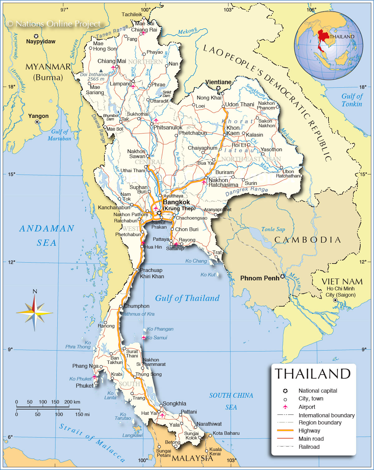 Political Map of Thailand Map based on a UN map. Source: UN Cartographic Section |
|||||||||||
| Cities in Thailand Map shows the location of following Thai cities and towns: Aranyaprathet, Ayutthaya (formerly the second Siamese capital), Ban Takhun, Bangkok, Betong, Bua Yai, Buriram, Chachoengsao, Chaiyaphum, Chanthaburi (Gem city), Chiang Mai (largest and culturally most significant city in northern Thailand), Chiang Rai (base for hill tribe trekking), Chon Buri, Chumphon, Fang, Hat Yai, Hua Hin (seaside resort), Kalasin, Kanchanaburi (Bridge On The River Kwai), Khon Kaen (Isan capital), Krabi (a must visit beach town), Lampang, Loei, Mae Hong Son, Mae Sai, Mae Sariang, Mae Sot, Nakhon Pathom, Nakhon Phanom, Nakhon Ratchasima, Nakhon Sawan, Nakhon Si Thammarat, Nam Tok, Nan, Narathiwat, Nong Khai, Nonthaburi (part of the Bangkok Metropolitan Area and second most populous city) Pattani, Pattaya (notorious beach resort), Phang Nga, Phayao, Phetchabun, Phetchaburi, Phitsanulok, Phuket, Prachuap Khiri Khan, Ranong, Ratchaburi, Rayong, Roi Et, Sakon Nakhon, Samut Prakan, Sattahip, Songkhla, Sukhothai (the first Siamese capital, a UNESCO World Heritage historical park.), Sungai Kolok, Suphan Buri, Surat Thani, Surin, Tak, Thung Song, Trang, Trat, Ubon Ratchathani, Udon Thani, Uthai Thani, Uttaradit, Yala, and Yasothon. | More about Thailand: Cities: Country: Thailand statistical key figures. Continent: Administrative Divisions of ThailandThailand is traditionally divided into 4 regions: North, Central, Isan (Eastern-Thailand), and Southern Thailand.Today for various reasons Thailand is divided into 6 regions, or more precisely 6 regional groups of Thai provinces. The regions are: Central Thailand, including the Thai capital of Bangkok, Eastern Thailand, Northern Thailand, Northeast (Isan), Southern Thailand and Western Thailand. This regions are furthermore divided into all in all 75 provinces (จังหวัด, changwat) which all are named after their capital, beside the provinces there are 2 special governed districts, namely: the capital city of Bangkok (in Thai: Krung Thep Mahanakhon) and the city of Pattaya. |
Weather Conditions Bangkok:
Weather Conditions Chiang Mai:
|
Explore More:
Related Consumer Information:
|
||||||||
Maps of other countries in Southeast and Eastern Asia: Bangladesh Map, Bhutan Map, Cambodia Map, China Map, India Map, Indonesia Map, Japan Map Korea (North), Korea (South), Laos Map, Malaysia Map, Maldives Map, Mongolia Map, Myanmar Map Nepal Map, Pakistan Map, Philippines Map Singapore Map, Sri Lanka Map, Taiwan Map, Vietnam Map | |||||||||||
One World - Nations Online .:. let's care for this planet Every nation is responsible for the current state of our world. |
| Site Map
| Information Sources | Disclaimer: Privacy Policy, etc. Contact: [email protected] | Copyright © 1998-2021 :: nationsonline.org |

