
| Home |
|
|
|
___ Political Map of Mongolia | |
About Mongolia |
|
| Mongolia is a vast and sparsely populated, landlocked country in eastern Asia between Russia to the north and China to the south, east of Kazakhstan. With an area of 1,564,100 km² Mongolia is twice the size of Turkey or slightly smaller than Alaska. The country is known as the "Land of the Eternal Blue Sky" and as the "Land of the Horse". The geography of Mongolia offers a variety of landscapes, even if much of the country consists of steppes, there is the Gobi Desert to the south and the more cooler and mountainous regions with the lush grassy steppe area of the Khangai Mountains to the north and the the Altai mountain range in west and south west. Highest mountain is Khüiten Peak of Nayramadlin Orgil mountain (Huyten Orgil) with 4,374 m in the western corner of Mongolia. Capital city of Mongolia is Ulaanbaatar (also Ulan Bator; pop. 1 million). Official language is Mongolian. Map is showing Mongolia and the surrounding countries with international borders, provincial boundaries, the national capital, provincial capitals, major cities, main roads, railroads and major airports. |
 Bookmark/share this page |
 One World - Nations Online all countries of the world |
|
|
||
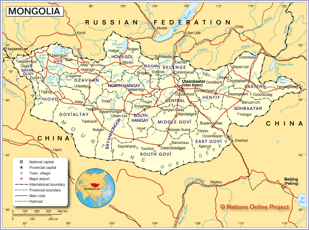 Political Map of Mongolia Map based on a UN map. Source: UN Cartographic Section |
|||||||
| Cities and Towns in Mongolia Largest cities and towns in Mongolia with more than 10,000 inhabitants: Ulaanbaatar (1 million people), Erdenet (second largest city 83,000), Darkhan (75,000), Choibalsan (39,000), Mörön (36,000), Nalaikh (30,000), Bayankhongor (30,000), Ölgii (29,000), Khovd (29,000), Arvaikheer (27,000), Ulaangom (27,000), Baganuur (22,000), Tsetserleg (20,000), Sükhbaatar (20,000), Dalanzadgad (19,000), Sainshand (19,000), Züünkharaa (18,000), Uliastai (17,500), Öndörkhaan (17,000), Altai (15,500), Baruun-Urt (14,000), Zuunmod (13,500), Zamyn-Üüd (13,300), Bulgan (11,300) and Mandalgovi (11,000) |
More about Mongolia Cities: Country: Mongolia key statistical data. Continent: |
Ulaanbaatar Weather Conditions
|
Related Consumer Information: |
||||
Maps of other countries in Southeast and Eastern Asia: Bangladesh Map, Bhutan Map, Cambodia Map, China Map, India Map, Indonesia Map, Japan Map Korea (North), Korea (South), Laos Map, Malaysia Map, Myanmar Map Nepal Map, Pakistan Map, Philippines Map Singapore Map, Sri Lanka Map, Taiwan Map, Thailand Map, Vietnam Map | |||||||
One World - Nations Online .:. let's care for this planet Every nation is responsible for the current state of our world. |
| Site Map
| Information Sources | Disclaimer: Privacy Policy, etc. Contact: [email protected] | Copyright © 1998-2021 :: nationsonline.org |
