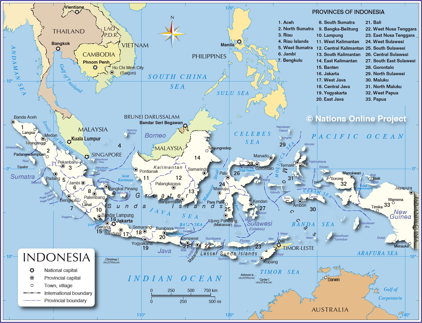
About Indonesia
The map shows the islands of Indonesia, officially the Republic of Indonesia, since August 1945 an independent island nation. It has land borders with
Malaysia (on Borneo),
Papua
New Guinea (on the island of New Guinea), and
Timor-Leste (on Timor island); it also shares maritime borders with
Australia,
India,
Palau, the
Philippines,
Singapore,
Thailand,
Vietnam, and
China (due to Chinese claims at the Riau Islands).
Administrative divisions of Indonesia
The country is divided into 34 provinces, the provinces are:
(in parenthesis: the provinces in the Indonesian language - followed by the province capital)
Sumatra
Sumatra is situated south of Peninsular Malaysia; it forms the extreme west of Indonesia. Sumatra is the sixth largest island in the world.
1. Aceh (Nanggroe Aceh Darussalam) - Banda Aceh
2. North Sumatra (Sumatera Utara) -
Medan
3. Riau - Pekanbaru
4. Riau Islands (Kepulauan Riau) - Tanjung Pinang
5. West Sumatra (Sumatera Barat) - Padang
6. Jambi - Jambi (city)
7. Bengkulu - Bengkulu (city)
8. South Sumatra (Sumatera Selatan) - Palembang
9. Bangka-Belitung (Kepulauan Bangka-Belitung) - Pangkal Pinang
10. Lampung - Bandar Lampung
Kalimantan
Kalimantan is the Indonesian name for the island of Borneo.
Indonesia shares the island with Malaysia and Brunei.
Its provinces on the island are:
11. West Kalimantan (Kalimantan Barat) - Pontianak
12. Central Kalimantan (Kalimantan Tengah) - Palangkaraya
13. South Kalimantan (Kalimantan Selatan) - Banjarmasin
14. East Kalimantan (Kalimantan Timur) - Samarinda
(14.) North Kalimantan (Kalimantan Utara) - Tanjung Selor
The province of North Kalimantan was created in 2012 by separating the area from the province of Kalimantan Timur.
Java
Java is one of the four Greater Sunda Islands.
The Indonesian capital Jakarta also lies on Java.
16. Jakarta - Jakarta
15. Banten - Serang
17. West Java (Jawa Barat) -
Bandung
18. Central Java (Jawa Tengah) - Semarang
19. Yogyakarta Special Region - Yogyakarta (city)
20. East Java (Jawa Timur) -
Surabaya
Lesser Sunda Islands
The archipelago of the Lesser Sunda Islands consists of six large and numerous small islands located east of Java. The main islands are, from west to east: Bali, Lombok, Sumbawa, Flores, Sumba, Timor, the Alor archipelago, the Barat Daya Islands, and the Tanimbar Islands.
21. Bali - Denpasar
22. West Nusa Tenggara (Nusa Tenggara Barat) - Mataram, on the island of Lombok
23. East Nusa Tenggara (Nusa Tenggara Timur) - Kupang, on the island of Timor
Sulawesi
Sulawesi is one of the four Greater Sunda Islands, situated to the east of Borneo.
24. West Sulawesi (Sulawesi Barat) - Mamuju
25. South Sulawesi (Sulawesi Selatan) - Ujung Pandang (Makassar)
26. Central Sulawesi (Sulawesi Tengah) - Palu
27. South East Sulawesi (Sulawesi Tenggara) - Kendari
28. Gorontalo - Gorontalo (city)
29. North Sulawesi (Sulawesi Utara) - Manado
Maluku islands (Moluccas)
The Maluku Islands are an archipelago in the eastern part of Indonesia.
30. Maluku - Ambon (city) located on the southern part of Ambon Island.
31. North Maluku (Maluku Utara) - Sofifi
Papua
Papua is the largest and easternmost province of Indonesia; the province occupies the western part of the island of New Guinea.
32. West Papua (Papua Barat) - Manokwari
33. Papua - Jayapura
More about Indonesia
 Silhouettes of stupas during sunrise in the Borobudur Temple Compound, Indonesia. The temple complex ix one of the greatest Buddhist monuments in the world. Since 1991, Borobudur Temple Compounds is a UNESCO World Heritage Site.
Image: CEphoto, Uwe Aranas
Indonesia is the largest archipelago in the world. The island nation is scattered over both sides of the equator in Maritime Southeast Asia, between the
South China Sea and the Pacific Ocean (in the north) and the Indian Ocean (in the south). Indonesia consists of more than 17,000 islands, many of them of volcanic origin. The largest islands are Sumatra, Java, Borneo (known as "Kalimantan" in Indonesia), Sulawesi, also known as the Greater Sunda Islands, and New Guinea. Most of the larger islands are mountainous, with peaks ranging between 3,000 to 3,800 m.
The country covers a land
area of 1,904,569 km², making it the largest country situated only on islands, and the largest country in South East Asia. The combined archipelago is more than five times the size of
Germany, or slightly smaller than three times the size of the US state of
Texas.
Indonesia is the fourth most populous country in the world with a
population of 238 million people and hundreds of ethnic groups with more than 700 indigenous local languages. The country's largest city and capital is
Jakarta.
The official
language and the country's lingua franca is Bahasa Indonesia, a Malay based language. The main religions are Islam (87%) and Christianity (10%).
The island nation is known for its beaches, volcanoes, Komodo dragons, orangutans, as well as for its slash-burn practice which destroys rainforests and wildlife habitats and causes severe air pollution.
For almost 200 years, from the late 17th century onwards, large parts of the archipelago were ruled by the Dutch East India Company (
Netherlands), a trade guild with quasi-governmental powers.
During World War II,
Japan invaded the archipelago and effectively ended Dutch rule.