 |
|
___ Map of Sri Lanka | |
About Sri Lanka |
|
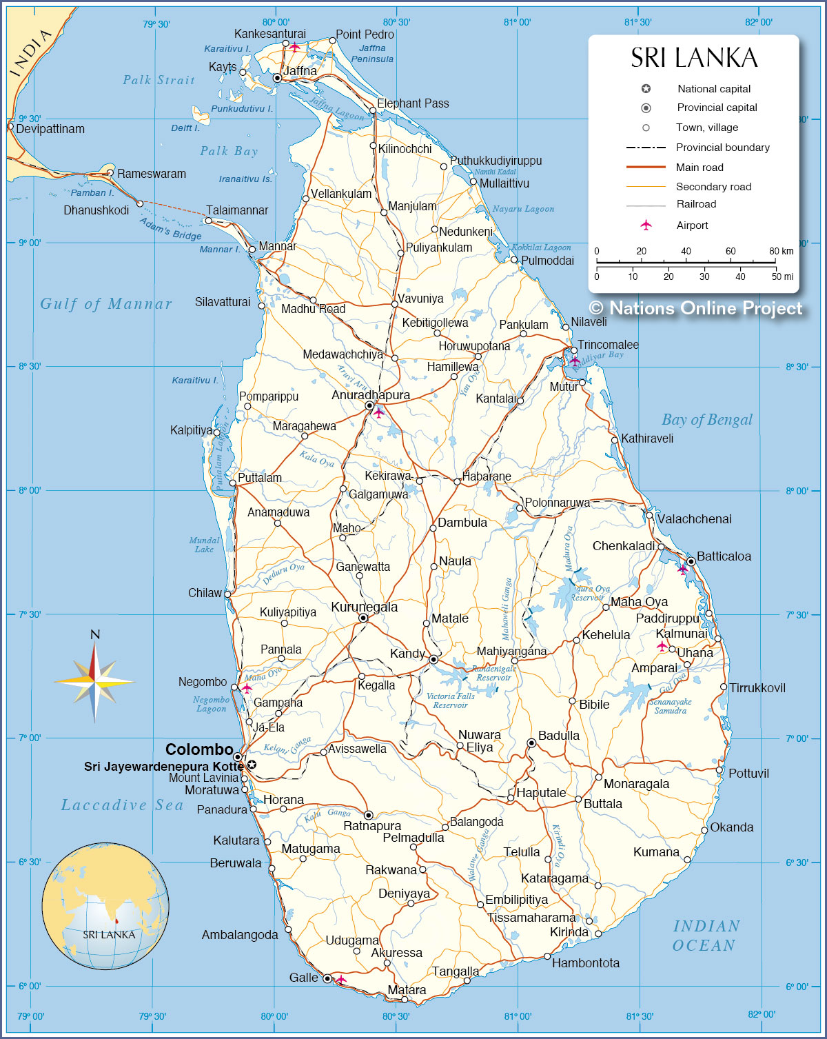
| Sri Lanka is an archipelagic state, consisting of the main island and a number of small islands, located between the Laccadive Sea in west and the Bay of Bengal in east, about 30 km (19 mi) south east of the southern coast of India. In 1948, British Ceylon was granted independence. In 1972 the island became a republic within the Commonwealth, and its name was changed to Sri Lanka. The country shares maritime borders with the Maldives and India. With an area of 65,610 km² Sri Lanka is somewhat larger than twice the size of Belgium or slightly larger than the U.S. state West Virginia. Sri Lanka's landscape is mostly low, it has flat to rolling coastal plains, and there are mountains in south-central interior. Highest elevation is at Pidurutalagala, (Mount Pedro; 2,524 m) in Central province. The island has a tropical climate moderated by ocean winds. Sri Lanka has a population of 21.2 million people (in 2016). Official capital is Sri Jayawardenepura Kotte, largest city is Colombo, spoken languages are Sinhala (official and national language) 74%, Tamil (national language) 18%, other 8%. About 10 % speak English as a second language. Map is showing the island of Sri Lanka with provincial capitals, major cities and towns, main roads, railroads and major airports. |
 Bookmark/share this page 
|
 One World - Nations Online all countries of the world |
|
|
||
 Map of Sri Lanka Map based on a UN map. Source: UN Cartographic Section |
|||||||
| Cities and towns in Sri Lanka Map shows the location of following Sri Lankan cities and towns: NORTHERN Province: Elephant Pass (Gateway to Jaffna), Jaffna (capital of the Northern Province), Kankesanturai, Kayts, Kilinochchi, Madhu Road, Manjulam, Mannar, Mullaittivu, Nedunkeni, Point Pedro, Puliyankulam, Puthukkudiyiruppu, Silavatturai, Talaimannar, Vavuniya, Vellankulam NORTH CENTRAL Anuradhapura (one of the ancient capitals, today capital of North Central Province), Habarane, Hamillewa, Horuwupotana, Kebitigollewa, Kekirawa, Maragahewa, Medawachchiya, Polonnaruwa NORTH WESTERN Pannala, Kuliyapitiya, Kurunegala, Chilaw, Ganewatta, Maho, Anamaduwa, Galgamuwa, Puttalam, Kalpitiya, Pomparippu EASTERN Province: Amparai, Batticaloa, Chenkaladi, Kalmunai, Kantalai, Kathiraveli, Kehelula, Kumana, Maha Oya, Mutur, Nilaveli, Okanda, Paddiruppu, Pankulam, Pottuvil, Pulmoddai, Tirrukkovil, Trincomalee, Uhana, Valachchenai CENTRAL Province: Dambula, Kandy (second largest city in the country), Matale, Naula, Nuwara Eliya SOUTHERN Province: Akuressa, Ambalangoda, Galle, Hambontota, Kirinda, Matara, Tangalla, Tissamaharama, Udugama WESTERN Province: Beruwala, Colombo (major seaport, largest city and cultural center of Sri Lanka), Gampaha, Horana, Ja-Ela, Kalutara, Matugama, Moratuwa, Mount Lavinia, Negombo, Panadura, Sri Jayewardenepura Kotte (New Capital Territory, seat of the Parliament of Sri Lanka and de jure capital) SABARAGAMUWA Province: Balangoda, Embilipitiya, Kegalla, Pelmadulla, Rakwana, Ratnapura (the "City of Gems", famous for the trade of precious stones, capital city of Sabaragamuwa Province) UVA Province: Badulla (capital, known for tea trade), Bibile, Buttala, Haputale, Kataragama, Monaragala, and Telulla. |
More about Sri Lanka: Cities: Country: Sri Lanka key statistical data. Continent: |
Weather Conditions at Colombo Airport: |
Related Consumer Information: |
||||
Maps of other countries in Southeast and Eastern Asia: Bangladesh Map, Bhutan Map, Cambodia Map, China Map, India Map, Indonesia Map, Japan Map Korea (North), Korea (South), Laos Map, Malaysia Map, Maldives Map, Mongolia Map, Myanmar Map Nepal Map, Pakistan Map, Philippines Map, Singapore Map, Taiwan Map, Thailand Map, Vietnam Map | |||||||
One World - Nations Online .:. let's care for this planet Every nation is responsible for the current state of our world. |
| Site Map
| Information Sources | Disclaimer: Privacy Policy, etc. Contact: [email protected] | Copyright © 1998-2021 :: nationsonline.org |