Nations Online
All Countries in the World
Nations Online All Countries in the World | |
| Home |
___ Famous Landmarks - Satellite View of the Empire State Building, Manhattan |
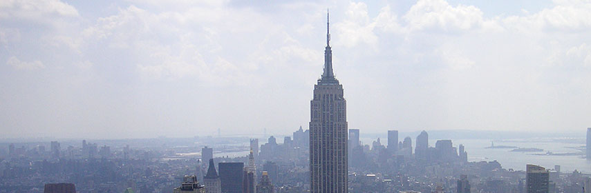 Empire State Building, Manhattan, NYC |
About the Empire State BuildingSatellite view is showing the Empire State Building, New York City,The Empire State Building, the 84 year old iconic building is still dominating the cityscape and it is is both a New York City and a U.S. National Historic Landmark. The world famous Art Deco skyscraper was designed by Gregory Johnson and the architectural firm Shreve, Lamb & Harmon Associates and built in just 16 months on the previous site of the renowned Waldorf Astoria Hotel. The Empire State Building opened 1st May 1931, and it remained the tallest skyscraper in the world until 1972 when the World Trade Center opened. On the 86th-floor of the Empire State Building there is one of the most popular open outdoor observation decks in the world, it offers a stunning 360-degree view of New York City and it's been visited by over 3.5 million people each year. Empire State Building in numbers: Height from base to Antenna/Spire 443.2 m (1,454 ft) Height from base to top 381 m (1,252 ft) 102 floors Built between 1930 and 1931. Curiosity: the building's Art Deco spire was originally designed to be a mooring mast and depot for airships. The 103rd floor was originally a landing platform with a dirigible gangplank. The check-in counter was in the 86th-floor observation deck. A particular elevator was supposed to transport passengers from the 86th to the 102nd floor, after they checked in. |
||
|
φ Latitude, λ Longitude (of Map center; move the map to see coordinates): , |
||
| Sorry! Google's pricing policy has made it impossible for us to continue showing Google Maps. We apologize for any inconvenience. Google Map: Satellite View of Empire State Building, New York City, USA. (Make sure 3D Buildings is checked in the Layers panel in Google Earth) |
Bookmark/share this page |
|
| previous landmark: Clock Tower, Palace of Westminster, London | next landmark: Forbidden City, Beijing, China | |
More about the United States: Landmarks: City: State: Country: Other Major U.S. Cities: Atlanta, Atlantic City, Austin, Baltimore, Boston, Chicago, Cincinnati, Cleveland, Columbia, Columbus, Dallas, Denver, Detroit, Honolulu, Houston, Indianapolis, Kansas City (MO), Las Vegas, Los Angeles, Memphis, Minneapolis, Nashville, New Orleans, Oklahoma City, Orlando, Philadelphia, Phoenix, Portland, Saint Louis, San Antonio, San Diego, San Francisco, Santa Fe, Washington D.C. Others: External Links: Empire State Building Official website of the Empire State Building. Wikipedia: Empire State Building Wikipedia article about the Empire State Building. |
Explore more:
Related Consumer Information:
|
|
Map Help [ show ]  |
||
One World - Nations Online .:. let's care for this planet Promote that every nation assumes responsibility for our world. Nations Online Project is made to improve cross-cultural understanding and global awareness. More signal - less NOISE |
| Site Map
| Information Sources | Disclaimer | Copyright © 1998-2023 :: nationsonline.org |
