
| Home |
|
|
|
___ Administrative Map of Burkina Faso |
|
Burkina Faso is a landlocked country in western Africa partly in the Sahel (in north), with a population of 18.5 million (in 2015); capital city is Ouagadougou. With an area of 274,222 km² Burkina is more than twice the size of Greece or slightly larger than the U.S. state of Colorado. Spoken languages are French (official), and indigenous languages. Former name (until 1984) Upper Volta. Border Countries are Benin, Cote d'Ivoire, Ghana, Mali, Niger, Togo Administrative Divisions: Burkina Faso is divided into 13 administrative regions and 45 provinces. Regions of Burkina Faso The regions are (capitals in parentheses): Boucle du Mouhoun (Dédougou), Cascades (Banfora), Centre-Est (Tenkodogo), Centre-Nord (Kaya), Centre-Ouest (Koudougou), Centre-Sud (Manga), Est (Fada N'gourma), Hauts-Bassins (Bobo Dioulasso), Nord (Ouahigouya), Plateau-Central (Ziniaré), Sahel (Dori) and Sud-Ouest (Gaoua). Map is showing Burkina Faso and the surrounding countries with international borders, provinces boundaries, the location of the national capital, as well as region and province capitals. |
 Bookmark/share this page |
 One World - Nations Online All Countries of the World |
|
|
||
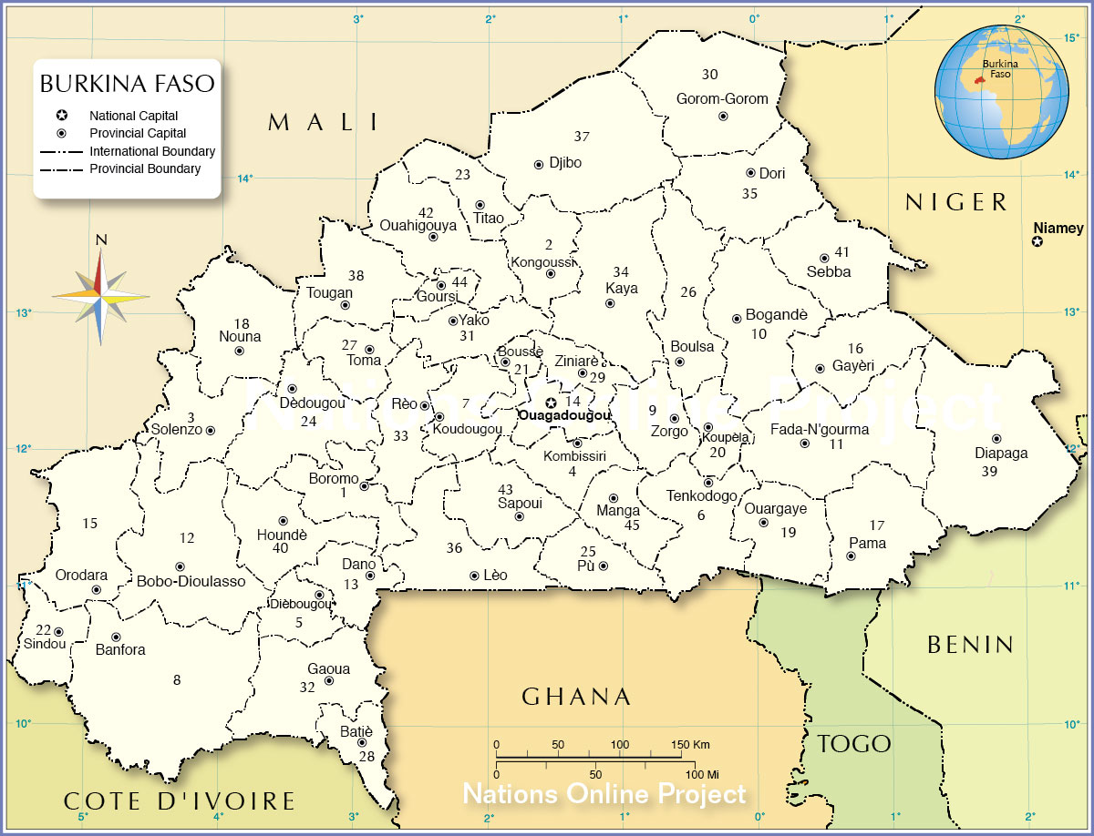 Administrative Map of Burkina Faso Map based on a UN map. Source: UN Cartographic Section | ||||
Burkina Faso ProvincesThe number on the map indicates the province (capitals in parentheses) |
||||
|
1. Balé (Boromo) 2. Bam (Kongoussi) 3. Banwa (Solenzo) 4. Bazèga (Kombissiri) 5. Bougouriba (Diébougou) 6. Boulgou (Tenkodogo) 7. Boulkiemdè (Koudougou) 8. Comoè (Banfora) 9. Ganzourgou (Zorgho) |
10. Gnagna (Bogandé) 11. Gourma (Fada N'gourma) 12. Houet (Bobo-Dioulasso) 13. Ioba (Dano) 14. Kadiogo (Ouagadougou) 15. Kènèdougou (Orodara) 16. Komondjari (Gayéri) 17. Kompienga (Pama) 18. Kossi (Nouna) 19. Koulpélogo (Ouargaye) |
20. Kourritenga (Koupéla) 21. Kourwéogo (Boussé) 22. Léraba (Sindou) 23. Loroum (Titao) 24. Mouhoun (Dédougou) 25. Nahouri (Pô also Pù) 26. Namentenga (Boulsa) 27. Nayala (Toma) 28. Noumbiel (Batié) 29. Oubritenga (Ziniaré) |
30. Oudalan (Gorom-Gorom) 31. Passorè (Yako) 32. Poni (Gaoua) 33. Sanguiè (Réo) 34. Sanmatenga (Kaya) 35. Sèno (Dori) 36. Sissili (Léo) 37. Soum (Djibo) 38. Sourou (Tougan) 39. Tapoa (Diapaga) |
40. Tuy (Houndé) 41. Yagha (Sebba) 42. Yatenga (Ouahigouya) 43. Ziro (Sapouy) 44. Zondoma (Gourcy) 45. Zoundwèogo (Manga) |
| More about Burkina Faso: Cities Country: Continent: |
Explore more
|
Current Weather Conditions Ouagadougou :
|
Related Consumer Information:
|
||||
|
Political Maps of other Countries in West Africa: Benin Map | Cape Verde Map | Côte d'Ivoire Map | Ghana Map | Guinea Map | Guinea-Bissau Map Liberia Map | Mali Map | Mauritania Map | Niger Map | Nigeria Map | Senegal Map | Sierra Leone Map | Togo Map |
|||||||
One World - Nations Online .:. let's care for this planet Every nation is responsible for the current state of our world. |
| Site Map
| Information Sources | Disclaimer: Privacy Policy, etc. Contact: [email protected] | Copyright © 1998-2021 :: nationsonline.org |
