Nations Online
All Countries in the World
Nations Online All Countries in the World | |
Home  |
___ Satellite View and Map of Colombia |
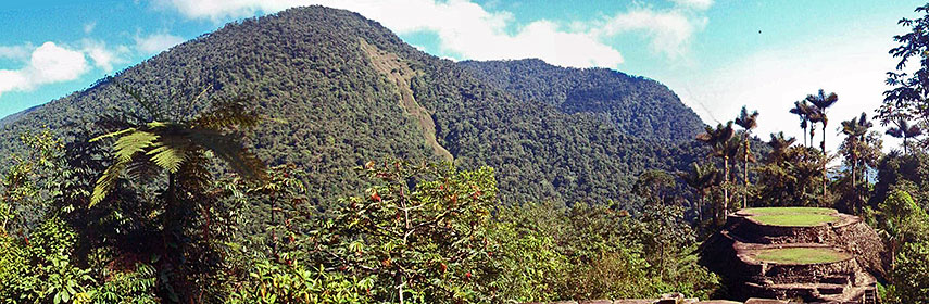 Ciudad Perdida, the Lost City, an archaeological site of an ancient city in Colombia's Sierra Nevada. Image: jmage |
About ColombiaMap is showing the South American country bordering the Caribbean Sea to the north, and the North Pacific Ocean in south west. Countries with international borders to Colombia are Brazil, Ecuador, Panama, Peru, and Venezuela, it shares maritime borders with Costa Rica, Dominican Republic, Haiti, Honduras, Jamaica, Nicaragua, and the Cayman Islands (United Kingdom).The area of Colombia is somewhat larger than twice the size of France or slightly less than twice the size of the U.S. state of Texas. Colombia's landscape offers flat coastal lowlands, central highlands, high Andes Mountains, and the Llanos, the lowland plains in east. Highest mountains are Pico Cristobal Colon, and Pico Simon Bolivar, both with an estimated elevation of 5700 m, the mountains are in the Sierra Nevada de Santa Marta, an isolated mountain range separated from the Andes. Colombia has a population of 48 million people (in 2015, official population clock The map shows Colombia with cities, towns, expressways, main roads and streets. To find a location use the form below. |
|
| To find a location type: street or place, city, optional: state, country. | Local Time Bogotá:
Friday-April-26 12:46
UTC/GMT -5 hours |
|
φ Latitude, λ Longitude (of Map center; move the map to see coordinates): , |
||||||
| Google Maps: Searchable Map of the Republic of Colombia. Some Points of interest: Bogotá with the Colombian National Museum and the Gold Museum, Bolívar Square, Bogotá Botanical Garden, Quinta de Bolívar Museum, the Primatial Cathedral of Bogotá, Monserrate, Tequendama Falls. Cartagena with Plaza Santo Domingo, Las Bóvedas, Castillo San Felipe de Barajas and Convento de la Popa. Arrecifes, Lake Guatavita, Ciudad Perdida, San Agustín Archaeological Park, Rosario Islands, Sierra Nevada de Santa Marta. |
Bookmark/share this page |
|||||
| More about Colombia: Cities: Country: Continent: | Current Weather Conditions Bogotá
|
Related Consumer Information:
|
||||
| Searchable Maps of other Countries in South America: Argentina, Brazil, Bolivia, Chile, Colombia, Ecuador, French Guiana Guyana, Paraguay, Peru, Suriname, Uruguay, Venezuela Maps of other Countries in South America: Argentina Map, Brazil Map, Bolivia Map, Chile Map, Colombia Map, Ecuador Map, French Guiana Map, Guyana Map, Paraguay Map, Peru Map, Suriname Map, Uruguay Map, Venezuela Map Countries and Territories of The Americas |
||||||
Map Help [ show ] |
||||||
One World - Nations Online .:. let's care for this planet Promote that every nation assumes responsibility for our world. Nations Online Project is made to improve cross-cultural understanding and global awareness. More signal - less NOISE |
| Site Map
| Information Sources | Disclaimer | Copyright © 1998-2023 :: nationsonline.org |

