
| Home |
|
|
|
___ Political Map of Colombia | |
About Colombia |
|
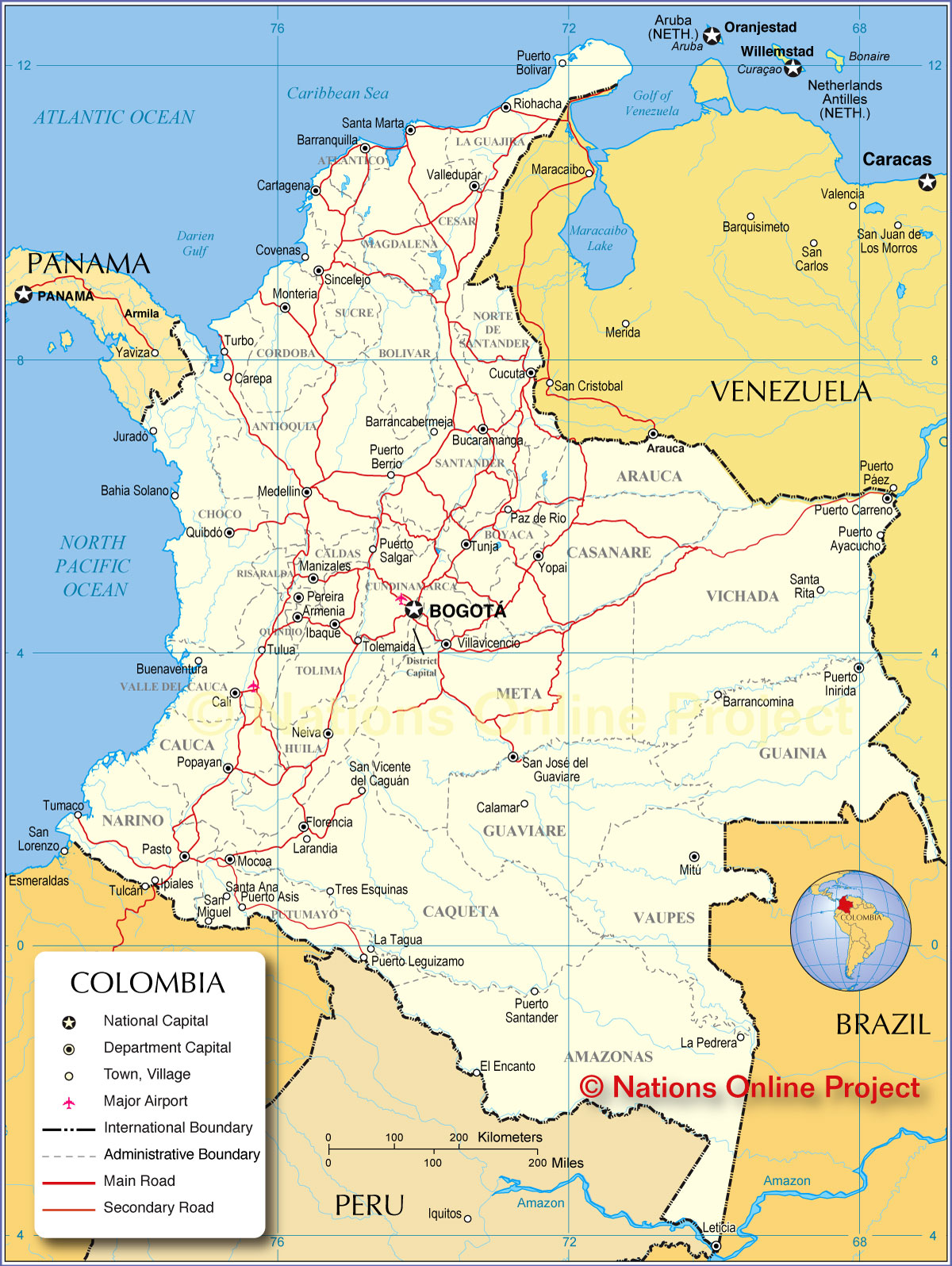
| Colombia is a country in northwestern South America that has a coastline on both the Atlantic and the Pacific oceans. It is bordered by Brazil, Ecuador, Panama, Peru, and Venezuela. The country additionally shares maritime borders with Costa Rica, Dominican Republic, Haiti, Honduras, Jamaica, Nicaragua, and the Cayman Islands (United Kingdom). Colombia occupies an area of 1,138,914 km², compared it is somewhat larger than twice the size of France or slightly less than twice the size of the U.S. state of Texas. Highest peak in the country is Pico Cristobal Colon with 5775 m (18,700 ft.), the mountain is part of the Sierra Nevada de Santa Marta range. The country has a population of 48 million people (in 2015, official population clock Capital and largest city is Bogotá, it lies at an altitude of 2,591 m (8,500 ft.), making Bogotá the highest city of this size in the world. Spoken languages are Spanish (official) and 68 ethnic languages and dialects. The detailed map below is showing Colombia and surrounding countries with international borders, departments boundaries, the national capital Bogotá, department capitals, major cities, main roads, and major airports. |
 Bookmark/share this page |
 One World - Nations Online all countries of the world |
|
|
||
 Map of Colombia |
|||||||
| Departments of Colombia and their capitals (in parentheses): Amazonas (Leticia), Antioquia (Medellín), Arauca (Arauca), Atlántico (Barranquilla), Bolívar (Cartagena), Boyacá (Tunja), Caldas (Manizales), Caquetá (Florencia), Casanare (Yopal), Cauca (Popayán), Cesar (Valledupar), Chocó (Quibdó), Córdoba (Montería), Cundinamarca (Bogotá), Guainía (Inírida), La Guajira (Riohacha), Guaviare (San José del Guaviare), Huila (Neiva), Magdalena (Santa Marta), Meta (Villavicencio), Nariño (Pasto), North Santander (Cúcuta), Putumayo (Mocoa), Quindío (Armenia), Risaralda (Pereira), Santander (Bucaramanga), Sucre (Sincelejo), Tolima (Ibagué), Valle del Cauca (Cali), Vaupés (Mitú), Vichada (Puerto Carreño), Capital District (Bogotá) |
More about Colombia Cities: Country: Continent: |
Bogotá Current Weather Conditions
|
Related Consumer Information:
|
||||
| Maps of other Countries in South America: Argentina Map, Brazil Map, Bolivia Map, Chile Map, Ecuador Map, French Guiana Map, Guyana Map, Paraguay Map, Peru Map, Suriname Map, Uruguay Map, Venezuela Map Maps of Countries in Central America: Belize Map, Costa Rica Map, El Salvador Map, Guatemala Map, Honduras Map, Nicaragua Map, Panama Map |
One World - Nations Online .:. let's care for this planet Every nation is responsible for the current state of our world. |
| Site Map
| Information Sources | Disclaimer: Privacy Policy, etc. Contact: [email protected] | Copyright © 1998-2021 :: nationsonline.org |
