Nations Online
All Countries in the World
Nations Online All Countries in the World | |
Home  |
___ Satellite View and Map of Guadeloupe |
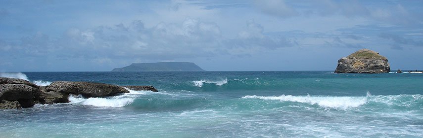 La Désirade island seen from the east coast of Guadeloupe. - Photo: Jayen466 |
About Guadeloupe Satellite view is showing Guadeloupe, which includes the butterfly shaped two main islands Basse-Terre and Grande Terre, those are separated by a narrow sea channel, the Salée River, and a number of smaller islands, altogether a group of seven islands (it were 9, but Saint-Barthélemy and the French part of Saint Martin island are since February 2007, no longer part of Guadeloupe). The smaller islands include Marie-Galante, La Désirade and Îles des Saintes. The archipelago is situated
between the Caribbean Sea and the North Atlantic Ocean, southeast of Puerto Rico. The total landarea of Guadeloupe is 1630 km², that is slightly smaller than two thirds of Luxembourg, or somewhat larger than half the size of Rhode Island. Satellite view is showing Guadeloupe, which includes the butterfly shaped two main islands Basse-Terre and Grande Terre, those are separated by a narrow sea channel, the Salée River, and a number of smaller islands, altogether a group of seven islands (it were 9, but Saint-Barthélemy and the French part of Saint Martin island are since February 2007, no longer part of Guadeloupe). The smaller islands include Marie-Galante, La Désirade and Îles des Saintes. The archipelago is situated
between the Caribbean Sea and the North Atlantic Ocean, southeast of Puerto Rico. The total landarea of Guadeloupe is 1630 km², that is slightly smaller than two thirds of Luxembourg, or somewhat larger than half the size of Rhode Island.Montainous Basse-Terre is of volcanic origin, it is home to the highest mountain peak in the Lesser Antilles, La Grande Soufrière, an active stratovolcano with a height of 1,467 m. Guadeloupe is an overseas department of France and is therefore in the European Union. It has a population of 403,000 inhabitants (2014). Guadeloupe's capital is Basse-Terre. Spoken languages are French (official) almost all locals speak also Creole patois. The map shows Guadeloupe with cities, towns, expressways, main roads and streets, and the location of the island's primary airport Pointe-à-Pitre International Airport (IATA code: PTP). Zoom out to find the location of L'Espérance Airport also known as Grand Case Airport (IATA code: SFG) on the island of St. Martin (on the French part of the Netherland Antilles). Zoom out to see the location of Guadeloupe within the Caribbean. To find a location use the form below. |
|
| To find a location type: street or place, city, optional: state, country. |
Local Time Guadeloupe:
Wednsday-July-15 15:24
UTC/GMT -4 hours |
One World - Nations Online .:. let's care for this planet Promote that every nation assumes responsibility for our world. Nations Online Project is made to improve cross-cultural understanding and global awareness. More signal - less NOISE |
| Site Map
| Information Sources | Disclaimer | Copyright © 1998-2024:: nationsonline.org |

