Nations Online
All Countries in the World
Nations Online All Countries in the World | |
Home  |
___ Satellite View and Map of the City of Malé, Maldives |
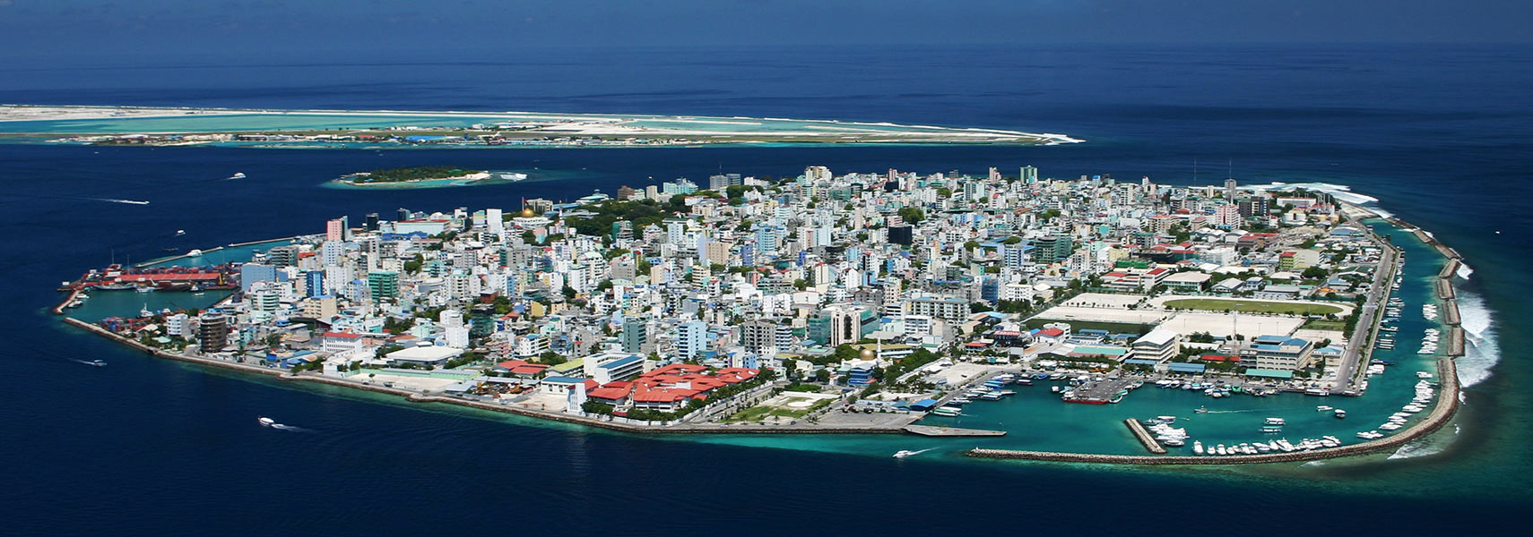 Bird's-eye view of Malé island with the densely populated capital of the Maldives. The long stretched island in back is Hulhulé Island, the site of Maldives Ibrahim Nasir International Airport (MLE). Image: Shahee Ilyas |
About Male Malé, jetty gateway and the Six Senses Resorts & Hotels Male Office and Mauritius Commercial Bank buildings in back. Image: Nattu Formerly Malé was the King's Island, a walled city surrounded by forts (kotte) and bastions. After the abolition of the monarchy in 1968, under the rule of President Ibrahim Nasi, the Royal Palace and the fortifications were destroyed and the city was remodeled. Today Male has a population of about 100,000 inhabitants. Spoken language is Dhivehi (Mahl). Malé points of interest. Most visitors to the Maldives head to the tropical beaches of the resort islands and atolls like Villingili, Meedhoo, Hithadhoo and Gan, but also the capital has some attractions. Historical sites: Malé Friday Mosque (oldest mosque in Malé, completed 1658, the building is on the tentative UNESCO World Heritage sites list as a unique example of sea-culture architecture) Palace: Mulee-aage Palace (the Muliaage is a palace in the historic center of Malé, it has been the official residence of all four presidents of the Maldives) Museums: National Museum (the museum exhibits a large collection of historical artifacts and documents, related to the history of the islands and the nation) The map shows a city map of Malé with main roads and streets, and the location of Malé International Airport (IATA code: MLE) on adjacent Hulhulé Island. The airport is the main point of entry to the Maldives. To find a location use the form below. To view just the map, click on the "Map" button. |
|
| To find a location type: street or place, city, optional: state, country. |
Local Time Maldives:
Friday-July-10 23:42
UTC/GMT +5 hours |
|
φ Latitude, λ Longitude (of Map center; move the map to see coordinates): , |
||||||
| Google Earth: Searchable Map and Satellite view of Malé, Maldives. City Coordinates: 4°10′30″N 73°30′32″E |
Bookmark/share this page |
|||||
| More about the Maldives: Country: Continent: External Links: Wikipedia: Malé | Weather Conditions Male
|
Related Consumer Information:
|
||||
Other Cities in South-Central Asia: Almaty, Ashgabat, Astana, Baku, Bishkek, Colombo, Dhaka, Dushanbe, Islamabad, Kabul, Kathmandu, New Delhi, Tashkent, Tehran, Thimphu |
||||||
Map Help [ show ] |
||||||
One World - Nations Online .:. let's care for this planet Promote that every nation assumes responsibility for our world. Nations Online Project is made to improve cross-cultural understanding and global awareness. More signal - less NOISE |
| Site Map
| Information Sources | Disclaimer | Copyright © 1998-2024:: nationsonline.org |

