Nations Online
All Countries in the World
Nations Online All Countries in the World | |
Home  |
___ Satellite View and Map of the City of Lomé, Togo |
About Lomé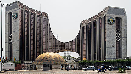 Building of the Ecowas Bank for Investment and Development (EBID) in Lomé, it is the principal financial institution of the Economic Community Of West African States (ECOWAS), established by the fifteen ECOWAS Member states. Image: Willem Heerbaart Today Lomé is Togo's largest city and the economic, administrative and industrial center of the country. It is the chief port of the nation. Lomé's port is situated to the east of the city. Togo's capital has a population of more than 1 million people in its metropolitan area (including the surrounding Golfe prefecture). Official language is French. 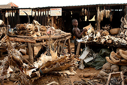 At the voodoo fetish market in Lomé, where you can buy items in use for Togolese traditional religion and medicine. Image: Dominik Schwarz Main attractions in the city are the Lomé Grand Market, Lomé's biggest marketplace, the Fetish Market (Marché des Féticheurs), when you're in need for some animal heads or voodoo charms, and the Village Artisanal that offers Togolese handicraft. The Togo National Museum offers a collection of African art of the history and culture of Togo, it presents also cultural and artistic exhibits. The Cathedral of the Sacred Heart (Cathédrale du Sacré Coeur) from colonial times, the main church of the Metropolitan Archdiocese of Lomé. The Grande Mosquee of Lomé. The Monument de l'Independance, the symbol of liberation of the Togolese people from the stranglehold of the French administration. The city is home to the University of Lomé, the largest university in the country. Just zoom in (+) and you will find yourself in the center of Togo's capital at the Monument de l'Independance. The map shows a city map of Lomé with expressways, main roads and streets, and the location of Lomé-Tokoin Airport (IATA code: LFW), Togo's international airport, about 6 km (via N1) northeast of the city center. To find a location use the form below. |
|
| To find a location type: street or place, city, optional: state, country. |
Local Time Togo:
Saturday-April-27 02:01
Time Zone: no time offset of GMT/UTC GMT/UTC 0 hour |
One World - Nations Online .:. let's care for this planet Promote that every nation assumes responsibility for our world. Nations Online Project is made to improve cross-cultural understanding and global awareness. More signal - less NOISE |
| Site Map
| Information Sources | Disclaimer | Copyright © 1998-2023 :: nationsonline.org |

