Nations Online
All Countries in the World
Nations Online All Countries in the World | |
Home  |
___ Satellite View and Map of Abuja, Nigeria |
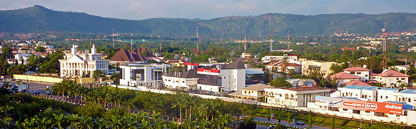 View of Abuja, Federal Capital Territory (FCT), located just north of the confluence of the Niger and Benue River. Image: Bryn Pinzgauer |
About AbujaIt officially became Nigeria's capital on 12 December 1991, when the military junta of Ibrahim Babangida relocated the capital from Lagos to Abuja. The city is under ongoing development, and some of the government ministries are still in Lagos, the country's primary city and the real center of business in the country. 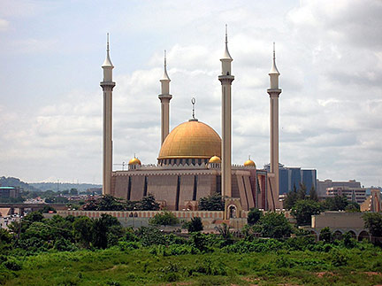 Abuja National Mosque, it is the national mosque of Nigeria, a country with one of the largest Muslim populations in West Africa (about 50% of Nigeria's population). Photo: Shiraz Chakera Abuja is a planned city, it was picked to be the capital of Nigeria in 1976, but construction was slow and expensive, obstructed also by the deeply entrenched corruption in the country. Located in the city, in the Three Arms Zone, is the Presidential Complex, it consists of the "State House" and "The Aso Rock Presidential Villa", the palatial residence of the president, the National Assembly, and the Supreme Court of Nigeria, as well as several other federal buildings. Among Abuja's landmarks are the National Mosque, the neo-gothic National Church of Nigeria, the primary Christian place of worship in the country, the Millennium Tower and Cultural Centre project, one of the many unfinished projects in the Central District of Abuja. When or if completed, the 170 m tower will be Nigeria's tallest structure. Just north of the city is Zuma Rock, the natural icon of the city, a huge 725 m high monolith, that dominates the landscape. The Map shows a city map of Abuja with expressways, and main roads, zoom out to find the location of Nnamdi Azikiwe International Airport (IATA code: ABV) 43 km (27 mi) west of the city's Central District. To find a location use the form below. To see just the map click on the "Map" Button. |
|
| To find a location type: street or place, city, optional: state, country. |
Local Time Abuja:
Wednsday-April-24 11:46
West Africa Time (WAT): UTC/GMT +1 h |
|
φ Latitude, λ Longitude (of Map center; move the map to see coordinates): , |
||||||
| Sorry! Google's pricing policy has made it impossible for us to continue showing Google Maps. We apologize for any inconvenience. Google Map: Searchable map/satellite view of the city of Abuja, Nigeria's capital. City Coordinates: 9°4′0″N 7°29′0″E |
Bookmark/share this page |
|||||
| More about Nigeria: Cities: Country: Continent: |
Current Weather Conditions Abuja:
External Links: City of Abuja Official website of the Federal Capital Territory and Abuja City. The Sun Nigeria news. Wikipedia: Abuja |
Related Consumer Information:
|
||||
Other Major Cities in West Africa Accra, Bamako, Banjul, Bissau, Conakry, Dakar, Freetown, Lomé, Monrovia, Niamey, Nouakchott, Ouagadougou, Porto-Novo, Praia, Yamoussoukro Searchable Maps of other Countries in West Africa: Benin | Burkina Faso | Cape Verde | Côte d'Ivoire | Gambia | Ghana | Guinea | Guinea-Bissau Liberia | Mali | Mauritania | Niger | Nigeria | Senegal | Sierra Leone | Togo |
||||||
Map Help [ show ] |
||||||
One World - Nations Online .:. let's care for this planet Promote that every nation assumes responsibility for our world. Nations Online Project is made to improve cross-cultural understanding and global awareness. More signal - less NOISE |
| Site Map
| Information Sources | Disclaimer | Copyright © 1998-2023 :: nationsonline.org |

